IMAGES TAKEN NEAR TO
Thundersley Park Road, BENFLEET, SS7 1EL
Introduction
This page details the photographs taken nearby to Thundersley Park Road, SS7 1EL by members of the Geograph project.
The Geograph project started in 2005 with the aim of publishing, organising and preserving representative images for every square kilometre of Great Britain, Ireland and the Isle of Man.

There are currently over 7.5m images from over14,400 individuals and you can help contribute to the project by visiting https://www.geograph.org.uk
Image Map
Images are licensed for reuse under creativecommons.org/licenses/by-sa/2.0
Notes
- Clicking on the map will re-center to the selected point.
- The higher the marker number, the further away the image location is from the centre of the postcode.
Image Listing (1 Images Found)
Images are licensed for reuse under creativecommons.org/licenses/by-sa/2.0
Image
Details
Distance
1
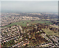
Aerial view of Boyce Hill golf course and South Benfleet
Boyce Hill golf course is the green swathe across the centre of the photo, occupying the centre of South Benfleet. The woodland above it is Thundersley Glen (also seen in Image). The sloping ground to the lower right borders onto Essex Way. We used to live in the small road at the bottom right, Norwood Drive, and the first winter after we moved there, this hillside was snow covered and used by skiers and tobogganers.
Image: © Edward Clack
Taken: 29 Mar 1990
0.23 miles