IMAGES TAKEN NEAR TO
Hazeldene, RAYLEIGH, SS6 9LB
Introduction
This page details the photographs taken nearby to Hazeldene, SS6 9LB by members of the Geograph project.
The Geograph project started in 2005 with the aim of publishing, organising and preserving representative images for every square kilometre of Great Britain, Ireland and the Isle of Man.

There are currently over 7.5m images from over14,400 individuals and you can help contribute to the project by visiting https://www.geograph.org.uk
Image Map
Images are licensed for reuse under creativecommons.org/licenses/by-sa/2.0
Notes
- Clicking on the map will re-center to the selected point.
- The higher the marker number, the further away the image location is from the centre of the postcode.
Image Listing (52 Images Found)
Images are licensed for reuse under creativecommons.org/licenses/by-sa/2.0
Image
Details
Distance
1
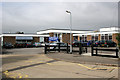
Down Hall Primary School
Down Hall Primary School, Brooklyn Drive entrance.
The School's postcode is SS6 9LW.
Image: © terry joyce
Taken: 12 Oct 2007
0.01 miles
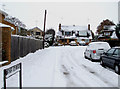
2
Deepdene Avenue
Taken at the junction of Image, looking towards the end of the road, which is a no through road, however there is a useful pathway that leads to Image, which is near to one of the entrances to Sweyne Park.
Image: © terry joyce
Taken: 1 Dec 2010
0.05 miles
3
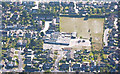
Aerial View Down Hall School
An aerial view of Down Hall Primary School.
See Image
Image: © terry joyce
Taken: 24 Sep 2003
0.05 miles
4
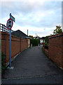
Shortest Bridleway
This is FP69 linking Canterbury Close and Deepdene Avenue. It is designated a Bridleway but is only around 20 metres long
Image: © terry joyce
Taken: 1 Nov 2012
0.06 miles
5
Dene Close
A very small Close, only a few properties, however there is a useful pathway that leads to Image and more importantly Image
Image: © terry joyce
Taken: 1 Dec 2010
0.08 miles
6
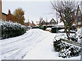
Canterbury Close
A Close of fairly modern houses. There is a pathway leading to Image
Image: © terry joyce
Taken: 1 Dec 2010
0.09 miles
7
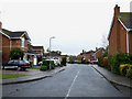
Harberts Way
This is one of the roads on a housing estate that is accessed from Image
Image: © terry joyce
Taken: 12 Jan 2011
0.09 miles
8
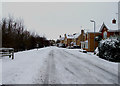
Downhall Park Way
This road is accessed from Image Sweyne Park is to the left of the picture.
Image: © terry joyce
Taken: 1 Dec 2010
0.10 miles
9
Deepdene Avenue
Taken from the junction of Image This view is looking towards the entrance of this road and the junction of Image
Image: © terry joyce
Taken: 1 Dec 2010
0.10 miles
10
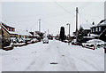
Brooklyn Drive
This road is a no through road accessed from Downhall Road. There is a pathway that leads through to Dene Close. Image is in this road.
Image: © terry joyce
Taken: 30 Nov 2010
0.10 miles