IMAGES TAKEN NEAR TO
Priory Chase, RAYLEIGH, SS6 9GX
Introduction
This page details the photographs taken nearby to Priory Chase, SS6 9GX by members of the Geograph project.
The Geograph project started in 2005 with the aim of publishing, organising and preserving representative images for every square kilometre of Great Britain, Ireland and the Isle of Man.

There are currently over 7.5m images from over14,400 individuals and you can help contribute to the project by visiting https://www.geograph.org.uk
Image Map (Loading...)


Getting Data...Please wait
Leaflet Map data © OpenStreetMap
Images are licensed for reuse under creativecommons.org/licenses/by-sa/2.0
Notes
- Clicking on the map will re-center to the selected point.
- The higher the marker number, the further away the image location is from the centre of the postcode.
Image Listing (49 Images Found)
Images are licensed for reuse under creativecommons.org/licenses/by-sa/2.0
Image
Details
Distance
1
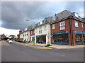
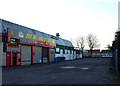
Fish & Chips
These new shops and flats are at the junction of Priory Chase and Rawreth Lane next to the ASDA store.
Image: © terry joyce
Taken: 1 Nov 2012
0.01 miles
2
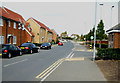
Priory Chase
The entrance to ASDA's can be seen towards the junction with Rawreth Lane.
Image: © terry joyce
Taken: 21 Oct 2010
0.02 miles
3
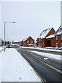
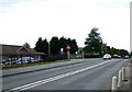
Priory Chase
Priory Chase is a no through road that leads to a housing estate that was built on what was Park School. The school was combined with Sweyne School to create Sweyne Park School, which is in grid Image, the car park entrance is where the silver people carrier is turning left. Image and Image are also accessed from this road.
Image: © terry joyce
Taken: 3 Dec 2010
0.02 miles
4
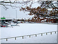
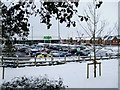
Building Land
This piece of land next to Image has been subject to planning applications for various types of buildings, so I thought I would record it before that happens.
Image: © terry joyce
Taken: 3 Dec 2010
0.02 miles
5
Rawreth Lane
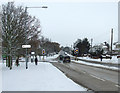
The traffic lights are the junction of Rawreth Lane and Priory Chase.
Priory Chase is a no through road, but leads to Image ,Image and Image
Image: © terry joyce
Taken: 3 Dec 2010
0.03 miles
6
ASDA Rayleigh
Taken from the path in Rawreth Lane, the ASDA store is accessed from Priory Chase.
Image: © terry joyce
Taken: 3 Dec 2010
0.04 miles
7
Rawreth Lane
The traffic lights are at the junction with Priory Chase; where the ASDA store is located.
The building to the left is Rawreth Court a home for the older people with mental health issues.
Image: © terry joyce
Taken: 21 Oct 2010
0.05 miles
8
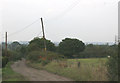
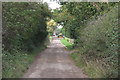
Hooley Drive
This pretty unmade road joins Parkhurst Road in Grid Image
The high ground at the top of the photo is South Woodham Ferrers on the north side of the River Crouch.
Image: © terry joyce
Taken: 15 Oct 2007
0.05 miles
9
Imperial Park, Rayleigh
This is part of Imperial Park, a small industrial estate on Rawreth Lane.
Image: © terry joyce
Taken: 9 Jan 2011
0.08 miles
10
Parkhurst Drive
This part of the pretty unmade road (Parkhurst Drive) is in the top left part of Grid TQ8092.
The start of the road is in Grid TQ7992 and the end of the road is in Grid TQ8093.
Image: © terry joyce
Taken: 15 Oct 2007
0.09 miles