IMAGES TAKEN NEAR TO
Drakes Way, RAYLEIGH, SS6 8BS
Introduction
This page details the photographs taken nearby to Drakes Way, SS6 8BS by members of the Geograph project.
The Geograph project started in 2005 with the aim of publishing, organising and preserving representative images for every square kilometre of Great Britain, Ireland and the Isle of Man.

There are currently over 7.5m images from over14,400 individuals and you can help contribute to the project by visiting https://www.geograph.org.uk
Image Map (Loading...)


Getting Data...Please wait
Leaflet Map data © OpenStreetMap
Images are licensed for reuse under creativecommons.org/licenses/by-sa/2.0
Notes
- Clicking on the map will re-center to the selected point.
- The higher the marker number, the further away the image location is from the centre of the postcode.
Image Listing (26 Images Found)
Images are licensed for reuse under creativecommons.org/licenses/by-sa/2.0
Image
Details
Distance
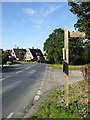
1
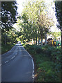
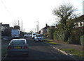
Hambro Hill
This is probably the steepest hill in Rayleigh. Behind the trees to the right is R E Wood & Sons Tree felling contractors.
Image: © terry joyce
Taken: 21 Oct 2010
0.08 miles
2
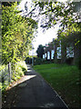
Houses, Hambro Hill
These houses are adjacent to the footpath on Hambro Hill, although vehicle access is from Drakes Way.
Image: © terry joyce
Taken: 21 Oct 2010
0.08 miles
3
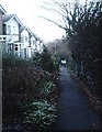
Hambro Hill, Rayleigh
The steepest hill in the area. The footpath is some way to the west of the road.
Image: © John Myers
Taken: 21 Jan 2007
0.08 miles
4
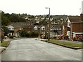
Houses along Upper Lambricks
This part of the road is quite high and has a good view over Rayleigh, which is seen in the distance.
Image: © Robert Edwards
Taken: 13 Aug 2008
0.10 miles
5
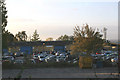
Car Storage
This Car Storage yard is just off the footpath from the top of Hambro Hill.
Image: © terry joyce
Taken: 20 Oct 2007
0.10 miles
6
Railway bridge on Hambro Hill, Rayleigh
Image: © David Howard
Taken: 26 Jul 2020
0.11 miles
7
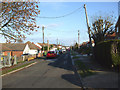
Hambro Avenue
This road links Hambro Hill with Downhall Road via Image It has approximately 50 properties of varying types, bungalows, houses, detached and semi detached.
Image: © terry joyce
Taken: 29 Nov 2010
0.11 miles
8
Hambro Avenue
This road links Hambro Hill with Downhall Road via Image It has approximately 50 properties of varying types, bungalows, houses, detached and semi detached.
Image: © terry joyce
Taken: 29 Nov 2010
0.12 miles
9
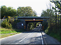
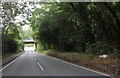
Railway Bridge
This railway bridge takes the Southend Victoria to London Liverpool Street line over Hambro Hill in Rayleigh.
Image: © terry joyce
Taken: 21 Oct 2010
0.13 miles
10
Footpath on the Hill
This is the top of Hambro Hill and the start of the Footpath that crosses the railway line.
Image: © terry joyce
Taken: 21 Oct 2010
0.14 miles