IMAGES TAKEN NEAR TO
Bellingham Lane, RAYLEIGH, SS6 7ED
Introduction
This page details the photographs taken nearby to Bellingham Lane, SS6 7ED by members of the Geograph project.
The Geograph project started in 2005 with the aim of publishing, organising and preserving representative images for every square kilometre of Great Britain, Ireland and the Isle of Man.

There are currently over 7.5m images from over14,400 individuals and you can help contribute to the project by visiting https://www.geograph.org.uk
Image Map
Images are licensed for reuse under creativecommons.org/licenses/by-sa/2.0
Notes
- Clicking on the map will re-center to the selected point.
- The higher the marker number, the further away the image location is from the centre of the postcode.
Image Listing (86 Images Found)
Images are licensed for reuse under creativecommons.org/licenses/by-sa/2.0
Image
Details
Distance
1
London Hill, Rayleigh
Top of London Hill.
Image: © John Myers
Taken: 30 Jul 2006
0.02 miles
2
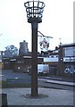
Millennium Beacon and Town Crest, Rayleigh
In Bellingham Lane. Holy Trinity in background.
Image: © John Myers
Taken: 18 Feb 2007
0.02 miles
3
Rayleigh Conservative Club in foreground
View taken from the top of the Holy Trinity Church at the top of the High Street showing the Rayleigh windmill as it was a few years ago when the Sports and Social Centre was still active.
Image: © Peter Rowlinson
Taken: Unknown
0.03 miles
4
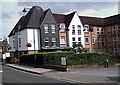
Homeregal House, Rayleigh
Sheltered housing apartments on the site of the old Regal cinema, which was anything but. It did, however, provide us kids with Saturday morning matinees for the princely sum of ninepence (4p now).
Image: © John Myers
Taken: 10 Jul 2007
0.03 miles
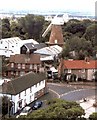
5
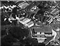
Aerial view of Rayleigh Conservative Club
This picture shows the windmill and the old Sports and Social Club at the centre the Rayleigh Conservative Club slightly above to the right. Also visible is the New Mill Hall to the lower right and part of the Mount to the lower left. Date can not be established currently.
Image: © Peter Rowlinson
Taken: Unknown
0.04 miles
6
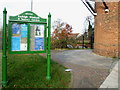
Path to the Sensory Garden
The sign indicates the location of the Sensory Garden at Image
The entrance can be seen at the end of the path.
Image: © terry joyce
Taken: 29 Nov 2010
0.04 miles
7
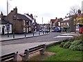
Rayleigh High Street
The view from the church of the Holy Trinity looking down the High Street.
Image: © Len Williams
Taken: 26 Dec 2011
0.04 miles
8
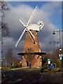
The Windmill, Rayleigh
The windmill was built on Rayleigh Mount in 1807 and operated until 1907. The sails and cap were then removed and it was converted to operate using steam/oil/electric motors, (in turn). The cap and sails were replaced in 1974 and the windmill is now a museum.
Image: © Len Williams
Taken: 26 Dec 2011
0.04 miles
9
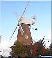
Rayleigh Windmill
A £340,000 revamp of the historic Rayleigh windmill including a structural renovation of the 19th century brick built building has now been completed.
The basic external brickwork has been repaired and the interior has been transformed to provide four storeys of modern display facilities which has turned the windmill into a major tourist and educational attraction in the county. See http://www.rochford.gov.uk/rdc/main.asp?page=515
Image: © Peter Rowlinson
Taken: 11 Nov 2007
0.04 miles