IMAGES TAKEN NEAR TO
Blenheim Close, HOCKLEY, SS5 5AX
Introduction
This page details the photographs taken nearby to Blenheim Close, SS5 5AX by members of the Geograph project.
The Geograph project started in 2005 with the aim of publishing, organising and preserving representative images for every square kilometre of Great Britain, Ireland and the Isle of Man.

There are currently over 7.5m images from over14,400 individuals and you can help contribute to the project by visiting https://www.geograph.org.uk
Image Map
Images are licensed for reuse under creativecommons.org/licenses/by-sa/2.0
Notes
- Clicking on the map will re-center to the selected point.
- The higher the marker number, the further away the image location is from the centre of the postcode.
Image Listing (10 Images Found)
Images are licensed for reuse under creativecommons.org/licenses/by-sa/2.0
Image
Details
Distance
1

Apex Corner
Shops on Plumberow Avenue. Not much has changed in nearly 15 years Image
Image: © John Myers
Taken: 25 Nov 2020
0.09 miles
2

Apex Corner
Shops on Plumberow Avenue, Hockley
Image: © John Myers
Taken: 14 Apr 2006
0.11 miles
3
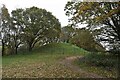
Plumberow Mount in Autumn
Late Iron Age Barrow
Image: © John Myers
Taken: 25 Nov 2020
0.17 miles
4
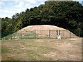
Plumberow Mount, Hockley
Late Iron Age hilltop barrow.
Image: © John Myers
Taken: 27 Jul 2006
0.18 miles
5
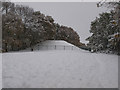
Plumberow Mount in the winter.
Plumberow Mount, Hockley a place for all seasons. The Mount remains a mystery as its true purpose has never been established, but is a fine place to visit on warm sunny days and on a day like today the surrounding slopes are a sledging paradise.
Image: © Ken Moore
Taken: 3 Dec 2010
0.18 miles
6
Marylands Nature Reserve, Hockley
View into a wooded section of Marylands Nature Reserve, which is managed by Hockley Parish Council: https://www.hockley-essex.gov.uk/facilities/parks-and-open-spaces/marylands-nature-reserve/
Image: © Roger Jones
Taken: 19 May 2022
0.22 miles
7

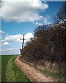
View west towards Crabtree Wood - #2
View west along Hockley Parish FP12 from its junction with FP13. Taken on 27.07.06, a day after a devastating fire swept through several large fields, destroying many acres of standing wheat. The large cracks, evident in the path, attest to the parched state of the area after several weeks of heatwave conditions.
Image: © John Myers
Taken: 27 Jul 2006
0.23 miles

9
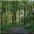
Footpath to Dome
Footpath north to Dome on Hockley Lower Road - Marylands Nature Reserve to right of shot.
Image: © John Myers
Taken: 5 Apr 2006
0.24 miles