IMAGES TAKEN NEAR TO
Samuel Bailey Drive, SS5 4FZ
Introduction
This page details the photographs taken nearby to Samuel Bailey Drive, SS5 4FZ by members of the Geograph project.
The Geograph project started in 2005 with the aim of publishing, organising and preserving representative images for every square kilometre of Great Britain, Ireland and the Isle of Man.

There are currently over 7.5m images from over14,400 individuals and you can help contribute to the project by visiting https://www.geograph.org.uk
Image Map
Images are licensed for reuse under creativecommons.org/licenses/by-sa/2.0
Notes
- Clicking on the map will re-center to the selected point.
- The higher the marker number, the further away the image location is from the centre of the postcode.
Image Listing (16 Images Found)
Images are licensed for reuse under creativecommons.org/licenses/by-sa/2.0
Image
Details
Distance
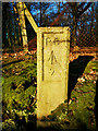
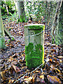
2
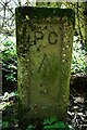
Old Boundary Marker in Hockley Woods
Prison Commission Boundary Marker in Hockley Woods against a wire fence at the northeast corner of the boundary of the former HM Prison Bullwood Hall. Hockley parish. Inscribed P C / ↑ / 3. Dated to the early 1960’s because the Prison Commission became part of the Home Office in 1963 and Bullwood Hall was built as a female borstal in the 1960's.
Milestone Society National ID: EX_PCBULL03em
Image: © L Chinea
Taken: 5 Apr 2021
0.12 miles
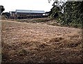
4
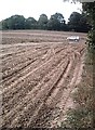
Potato Field
Deep, dusty ruts as the harvest goes on under bone-dry conditions.
Image: © John Myers
Taken: 3 Sep 2007
0.14 miles
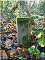
6
Old Boundary Marker of the former HM Prison Bullwood Hall
Prison Commission Boundary Marker by a fence post at a change in direction on the southern boundary of the former HM Prison Bullwood Hall. Rayleigh parish. Inscribed P C / ↑ / 7. Dated to the early 1960’s because the Prison Commission became part of the Home Office in 1963 and Bullwood Hall was built as a female borstal in the 1960's.
Milestone Society National ID: EX_PCBULL07em
Image: © L Chinea
Taken: Unknown
0.15 miles
7
Old Boundary Marker in Hockley Woods
Prison Commission Boundary Marker by a fence post at a change in direction towards the southeast corner of the boundary of the former HM Prison Bullwood Hall in Hockley Woods. Hawkwell parish. Inscribed P C / ↑ / 4. Dated to the early 1960’s because the Prison Commission became part of the Home Office in 1963 and Bullwood Hall was built as a female borstal in the 1960's.
Milestone Society National ID: EX_PCBULL04em
Image: © L Chinea
Taken: Unknown
0.16 miles
8
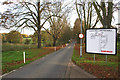
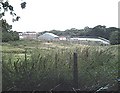
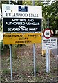
HMP Bullwood Hall
This is Bullwood Hall Lane and the entrance to HMP Bullwood Hall.
The Footpath is on the right just as this road gets to the lowest point.
Image: © terry joyce
Taken: 1 Nov 2007
0.16 miles
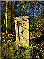
9
Old Boundary Marker in Hockley Woods
Prison Commission Boundary Marker inside a barbed wire fence at the northeast corner of the boundary of the former HM Prison Bullwood Hall in Hockley Woods. Hockley parish. Inscribed P C / ↑ / 2. Dated to the early 1960’s because the Prison Commission became part of the Home Office in 1963 and Bullwood Hall was built as a female borstal in the 1960's.
Milestone Society National ID: EX_PCBULL02em
Image: © L Chinea
Taken: Unknown
0.17 miles
10
Old Boundary Marker in Hockley Woods
Prison Commission Boundary Marker by a fence post at a change in direction on the southern boundary of the former HM Prison Bullwood Hall in Hockley Woods. Rayleigh parish. Inscribed P C / ↑ / 6. Dated to the early 1960’s because the Prison Commission became part of the Home Office in 1963 and Bullwood Hall was built as a female borstal in the 1960's.
Milestone Society National ID: EX_PCBULL06em
Image: © L Chinea
Taken: Unknown
0.18 miles