IMAGES TAKEN NEAR TO
Foulness Island, SOUTHEND-ON-SEA, SS3 9XH
Introduction
This page details the photographs taken nearby to SS3 9XH by members of the Geograph project.
The Geograph project started in 2005 with the aim of publishing, organising and preserving representative images for every square kilometre of Great Britain, Ireland and the Isle of Man.

There are currently over 7.5m images from over14,400 individuals and you can help contribute to the project by visiting https://www.geograph.org.uk
Image Map
Images are licensed for reuse under creativecommons.org/licenses/by-sa/2.0
Notes
- Clicking on the map will re-center to the selected point.
- The higher the marker number, the further away the image location is from the centre of the postcode.
Image Listing (6 Images Found)
Images are licensed for reuse under creativecommons.org/licenses/by-sa/2.0
Image
Details
Distance
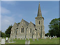
1
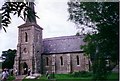
Foulness Island: St Mary the Virgin Church
Access to this island is severely restricted, and has been since, I believe, the Second World War. This photo was taken when there was a Flower Show on the Island, but even then you felt that you were being watched.
Image: © Andrew Smith
Taken: 1 Jul 2000
0.19 miles
2
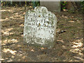
Foulness Island: St Mary the Virgin gravestone
One of many ancient gravestones in the mysterious churchyard at St Mary's, Churchend, on Foulness Island. This is the final resting place of Ionas Allin 'who departed this life in 1769'.
Image: © Julieanne Savage
Taken: 27 Dec 2006
0.19 miles
3
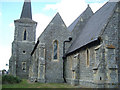
Foulness Island: St Mary the Virgin
Taken on the MOD controlled island of Foulness in Essex. Access for the general public is restricted. This is the East Wing of the church. The building depicted here was re-built in 1848 after the original church began to crumble.
Image: © Julieanne Savage
Taken: 27 Dec 2006
0.19 miles
4
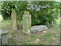
Foulness Island: St Mary the Virgin
Another interesting shot of some old graves outside the church. Many of the graves pre-date the existing building, going back hundreds of years to when habitation on the island was much smaller.
Image: © Julieanne Savage
Taken: 27 Dec 2006
0.19 miles
5
Foulness Island: St Mary the Virgin, Churchend
Stunning shot of this beautiful and seldom-visited church on the restricted MOD controlled island of Foulness. This shot looks east towards the side of the church showing the Victorian stonework. At time of taking the photograph my friend and I were being attacked by horseflies which were most prevalent on the island that day.
Image: © Julieanne Savage
Taken: 27 Dec 2006
0.19 miles
6
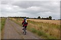
Track to Nase Wick
Taken on the day of a sponsored cycle event on Foulness Island. This track (which passes Nase Wick and rejoins road at the old school - now the Heritage Centre) was the only off-road section. The farm buildings at Nase Wick can be seen among the trees in the distance.
Image: © Trevor Harris
Taken: 13 Sep 2009
0.22 miles