IMAGES TAKEN NEAR TO
Picasso Way, SOUTHEND-ON-SEA, SS3 9XB
Introduction
This page details the photographs taken nearby to Picasso Way, SS3 9XB by members of the Geograph project.
The Geograph project started in 2005 with the aim of publishing, organising and preserving representative images for every square kilometre of Great Britain, Ireland and the Isle of Man.

There are currently over 7.5m images from over14,400 individuals and you can help contribute to the project by visiting https://www.geograph.org.uk
Image Map (Loading...)


Getting Data...Please wait
Leaflet Map data © OpenStreetMap
Images are licensed for reuse under creativecommons.org/licenses/by-sa/2.0
Notes
- Clicking on the map will re-center to the selected point.
- The higher the marker number, the further away the image location is from the centre of the postcode.
Image Listing (19 Images Found)
Images are licensed for reuse under creativecommons.org/licenses/by-sa/2.0
Image
Details
Distance
1
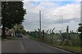
Wakering Road, Shoeburyness
The MoD firing range is on the right. They clearly can't use live bullets as it's right on a residential road. I hope.
Image: © David Howard
Taken: 25 May 2021
0.07 miles
2

Electrical transformers at MoD Shoeburyness
Next to the firing range
Image: © David Howard
Taken: 25 May 2021
0.07 miles
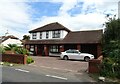
3
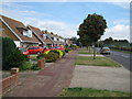
Shoebury: Wakering Road
These chalet-style bungalows overlook the MOD Shoeburyness compound beyond the fence on the right. The tree with the berries is a rowan.
Image: © Nigel Cox
Taken: 3 Aug 2008
0.09 miles
5
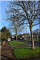
Wakering Road
Approaching the border with Rochford District. The Shoebury Ranges perimeter fence to right of shot
Image: © John Myers
Taken: 9 Jan 2015
0.12 miles
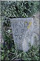
6
Old Boundary Marker by Wakering Road, Southend-on-Sea
Parish Boundary Marker by the UC road, in parish of Southend-on-Sea (Southend On Sea District), Wakering Road, in undergrowth.
Surveyed
Milestone Society National ID: EX_SOUS01pb.
Image: © Milestone Society
Taken: Unknown
0.12 miles
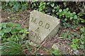
8
Old Boundary Marker by Wakering Road, south of Great Wakering
Estate Boundary Marker - War Department #70 by the UC road, in parish of Great Wakering (Rochford District), Wakering Road, in undergrowth, West side of road.
Surveyed
Milestone Society National ID: EX_WDSHOE78em.
Image: © Milestone Society
Taken: Unknown
0.13 miles
9

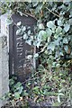
Old Boundary Marker by Wakering Road, Southend-on-Sea parish
Estate Boundary Marker - MOD by the UC road, in parish of Southend-on-Sea (Southend-on-Sea District), Wakering Road, next to Southern gatepost at range entrance.
Inscription reads:-
M.O.D.
^
S.N.
Surveyed
Milestone Society National ID: EX_MODSHO06em
Image: © Milestone Society
Taken: Unknown
0.14 miles
10
Old Boundary Marker by Wakering Road, Southend-on-Sea
Estate Boundary Marker - MOD by the UC road, in parish of Southend-on-Sea (Southend-on-Sea District), Wakering Road, next to northern gatepost at range entrance, East side of road.
Surveyed.
Milestone Society National ID: EX_MODSHO05em.
Image: © Milestone Society
Taken: Unknown
0.14 miles