IMAGES TAKEN NEAR TO
Raphael Drive, SOUTHEND-ON-SEA, SS3 9UP
Introduction
This page details the photographs taken nearby to Raphael Drive, SS3 9UP by members of the Geograph project.
The Geograph project started in 2005 with the aim of publishing, organising and preserving representative images for every square kilometre of Great Britain, Ireland and the Isle of Man.

There are currently over 7.5m images from over14,400 individuals and you can help contribute to the project by visiting https://www.geograph.org.uk
Image Map
Images are licensed for reuse under creativecommons.org/licenses/by-sa/2.0
Notes
- Clicking on the map will re-center to the selected point.
- The higher the marker number, the further away the image location is from the centre of the postcode.
Image Listing (4 Images Found)
Images are licensed for reuse under creativecommons.org/licenses/by-sa/2.0
Image
Details
Distance
1
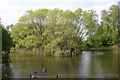
South-western lake, Friars Park, North Shoebury
The two lakes in Friars Park were until 1976 brick pits. 20,000 years ago the gravels of the area were covered with windblown silt or brickearth and from the mid-C19 North Shoebury and nearby Great Wakering became a centre for brickmaking. The last brickworks closed in 2005 and were in Star Lane just to the north of this point.
Image: © David Kemp
Taken: 23 Apr 2014
0.11 miles
2
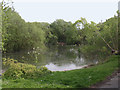
North-eastern lake in Friars Park, North Shoebury
The two lakes in Friars Park were until 1976 brick pits. 20,000 years ago the gravels of the area were covered with windblown silt or brickearth and from the mid-C19 North Shoebury and nearby Great Wakering became a centre for brickmaking. The last brickworks closed in 2005 and were in Star Lane just to the north of this point.
Image: © David Kemp
Taken: 23 Apr 2014
0.14 miles
3
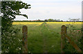
Footpath from Friars Park to Poynters Lane
The two posts seem to mark the boundary between the Southend and Rochford local authorities which runs from left to right. Until 2007 there were brickworks in this area but those in the vicinity of this particular point closed in 1976.
Image: © David Kemp
Taken: 23 Apr 2014
0.16 miles
4
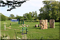
Friars Park, Shoeburyness
Until 1976 this was the site of brickworks.
Image: © David Kemp
Taken: 23 Apr 2014
0.19 miles