IMAGES TAKEN NEAR TO
Blyth Avenue, SOUTHEND-ON-SEA, SS3 9NH
Introduction
This page details the photographs taken nearby to Blyth Avenue, SS3 9NH by members of the Geograph project.
The Geograph project started in 2005 with the aim of publishing, organising and preserving representative images for every square kilometre of Great Britain, Ireland and the Isle of Man.

There are currently over 7.5m images from over14,400 individuals and you can help contribute to the project by visiting https://www.geograph.org.uk
Image Map
Images are licensed for reuse under creativecommons.org/licenses/by-sa/2.0
Notes
- Clicking on the map will re-center to the selected point.
- The higher the marker number, the further away the image location is from the centre of the postcode.
Image Listing (6 Images Found)
Images are licensed for reuse under creativecommons.org/licenses/by-sa/2.0
Image
Details
Distance
1
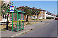
Caulfield Road, Shoeburyness
The bus shelter here in the Southend suburbs is served by Arriva's routes 7 and 8 which link Rayleigh with North Shoebury and Great Wakering via the city centre. Blyth Avenue leads off to the left.
Image: © Stephen McKay
Taken: 11 Aug 2022
0.11 miles
2
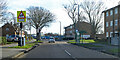
Delaware Road, Shoeburyness
The bus stops are called Thorpedene Library, and are served by route 2, which runs between Southend and Shoeburyness.
Image: © Robin Webster
Taken: 5 Feb 2023
0.19 miles
3
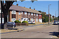
Delaware Road, Shoeburyness
A mixture of terraced houses and flats lines the north side of Delaware Road, seen here from its junction with Blyth Avenue. The housing stock here is obviously local authority built and contrasts noticeably with the private housing to the south.
Image: © Stephen McKay
Taken: 11 Aug 2022
0.19 miles
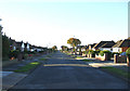
4
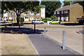
Blyth Avenue/Delaware Road, Shoeburyness
Houses and flats surround a small green on Delaware Road at the northern end of Blyth Avenue. Note the parched brown grass on the verges following a very hot dry spell.
Image: © Stephen McKay
Taken: 11 Aug 2022
0.20 miles
5
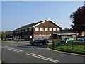
Thorpedene Centre
This is the Thorpedene Centre, it houses a Library, Community Centre and Clinic. It is located at the Junction of Maplin Way and Delaware Rd Thorpe Bay. The picture was taken looking northbound along Maplin Way
Image: © Glyn Baker
Taken: 16 Oct 2005
0.22 miles
6
St James Avenue
This is one of the roads on the Burges Estate.
Image: © terry joyce
Taken: 20 Oct 2010
0.23 miles