IMAGES TAKEN NEAR TO
Carpenters Close, SOUTHEND-ON-SEA, SS3 0LF
Introduction
This page details the photographs taken nearby to Carpenters Close, SS3 0LF by members of the Geograph project.
The Geograph project started in 2005 with the aim of publishing, organising and preserving representative images for every square kilometre of Great Britain, Ireland and the Isle of Man.

There are currently over 7.5m images from over14,400 individuals and you can help contribute to the project by visiting https://www.geograph.org.uk
Image Map (Loading...)


Getting Data...Please wait
Leaflet Map data © OpenStreetMap
Images are licensed for reuse under creativecommons.org/licenses/by-sa/2.0
Notes
- Clicking on the map will re-center to the selected point.
- The higher the marker number, the further away the image location is from the centre of the postcode.
Image Listing (10 Images Found)
Images are licensed for reuse under creativecommons.org/licenses/by-sa/2.0
Image
Details
Distance
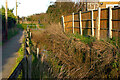
1
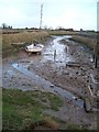
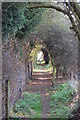
Footpath to Little Wakering Creek
A rather inauspicious start to what turned out to be an excellent walk (hitting the right tide, weather, time of day etc) from the head of Little Wakering Creek to Barling Ness and back.
Image: © Trevor Harris
Taken: 17 Jan 2013
0.09 miles
2
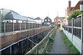
Pathway in Little Wakering
The path leads from Little Wakering Road (behind the camera) into Kimberley Road. It runs beside a stream that flows into Little Wakering Creek whose head is on the far side of the wall ahead.
Image: © David Kemp
Taken: 9 Mar 2021
0.11 miles
3
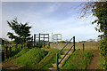
Steps at end of Kimberley Road, Little Wakering
The head of Little Wakering Creek is on the other side of the steps from which footpaths run either side of it.
Image: © David Kemp
Taken: 23 Feb 2021
0.14 miles
4
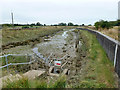
Head of Little Wakering Creek
The sluice is called 'Barling Creek Sluice'. Who is right, Ordnance Survey or Environment Agency?
Image: © Robin Webster
Taken: 11 Aug 2015
0.14 miles
5
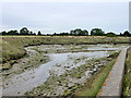
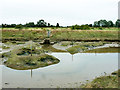
Little Wakering creek
Very mud filled.
Image: © Julieanne Savage
Taken: 2 Jan 2007
0.15 miles
6
Head of Little Wakering Creek
The sluice is called 'Barling Creek Sluice'. Who is right, Ordnance Survey or Environment Agency? Compare with this view taken over eight years earlier Image A gridiron (wooden) for boats to settle on up against the posts on the right has largely gone. A little further on, on the left, a small jetty has collapsed.
Image: © Robin Webster
Taken: 11 Aug 2015
0.15 miles
7
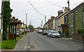
Little Wakering Road looking towards church
The church spire can be seen protruding from a roof to the left of the left-hand pole.
Image: © David Kemp
Taken: 30 Apr 2023
0.22 miles
8
Little Wakering Creek
In the middle, at the water's edge, is a Little Egret.
Image: © Robin Webster
Taken: 11 Aug 2015
0.22 miles
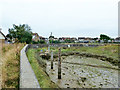
10
Sluice, Little Wakering Creek
A tidal flap, the usual in these parts. The sticks are navigation aids, although navigators these days must be very few - there was no sign today.
Image: © Robin Webster
Taken: 11 Aug 2015
0.24 miles