
IMAGES TAKEN NEAR TO
Little Wakering Hall Lane, SOUTHEND-ON-SEA, SS3 0HH
Introduction
This page details the photographs taken nearby to Little Wakering Hall Lane, SS3 0HH by members of the Geograph project.
The Geograph project started in 2005 with the aim of publishing, organising and preserving representative images for every square kilometre of Great Britain, Ireland and the Isle of Man.

There are currently over 7.5m images from over14,400 individuals and you can help contribute to the project by visiting https://www.geograph.org.uk
Image Map
Images are licensed for reuse under creativecommons.org/licenses/by-sa/2.0
Notes
- Clicking on the map will re-center to the selected point.
- The higher the marker number, the further away the image location is from the centre of the postcode.
Image Listing (4 Images Found)
Images are licensed for reuse under creativecommons.org/licenses/by-sa/2.0
Image
Details
Distance
1
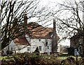
Little Wakering Hall
Though modified since, some of the house dates back to the fifteenth century.
Image: © David Kemp
Taken: 14 Feb 2006
0.04 miles
2
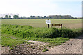
'Closed' footpath, Little Wakering
The OS map shows two footpaths here, one to the left and the other straight ahead across the field. Although the sign permits access to the former it forbids access to the latter.
Image: © David Kemp
Taken: 19 Apr 2019
0.21 miles
3
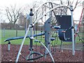
Wakering playground
Next to the Sports Centre.
Image: © Julieanne Savage
Taken: 2 Jan 2007
0.23 miles
4
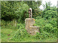
Old pump, Little Wakering
In a field belonging to Little Wakering Wick, its elevated position is unusual. There is no evidence the brickwork was part of a larger building on old maps. The location was first noted on maps as a well. Perhaps the idea was to protect the well from flooding.
Image: © Robin Webster
Taken: 11 Aug 2015
0.24 miles