IMAGES TAKEN NEAR TO
Lampits Hill, STANFORD-LE-HOPE, SS17 9NG
Introduction
This page details the photographs taken nearby to Lampits Hill, SS17 9NG by members of the Geograph project.
The Geograph project started in 2005 with the aim of publishing, organising and preserving representative images for every square kilometre of Great Britain, Ireland and the Isle of Man.

There are currently over 7.5m images from over14,400 individuals and you can help contribute to the project by visiting https://www.geograph.org.uk
Image Map
Images are licensed for reuse under creativecommons.org/licenses/by-sa/2.0
Notes
- Clicking on the map will re-center to the selected point.
- The higher the marker number, the further away the image location is from the centre of the postcode.
Image Listing (6 Images Found)
Images are licensed for reuse under creativecommons.org/licenses/by-sa/2.0
Image
Details
Distance
1
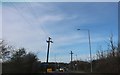
Lampits Hill at the junction of Southend Road
Image: © David Howard
Taken: 9 Mar 2019
0.04 miles
2
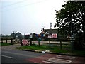
Ausonia Nurseries Corringham
This is a small nursery and garden centre on the B1420 just outside Corringham near the junction with a minor road to Stanford-le-Hope. The photo was taken looking west.
Image: © Glyn Baker
Taken: 7 Oct 2005
0.05 miles
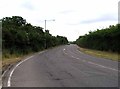
4
Lampits Hill & Southend Rd Junction
Looking along the B1420
Image: © Glyn Baker
Taken: 27 Apr 2020
0.06 miles
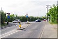
5
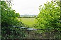
Meadow by Southend Rd
It has been a year or two since this gate has been used.
Image: © Glyn Baker
Taken: 27 Apr 2020
0.08 miles
6
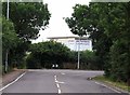
Southend Road
In the background is Performers College which is an independent Further ducation College for the Performing Arts accoring to their website.
Image: © Andrew Tatlow
Taken: 26 Jul 2013
0.17 miles