IMAGES TAKEN NEAR TO
Larkswood Road, STANFORD-LE-HOPE, SS17 9DF
Introduction
This page details the photographs taken nearby to Larkswood Road, SS17 9DF by members of the Geograph project.
The Geograph project started in 2005 with the aim of publishing, organising and preserving representative images for every square kilometre of Great Britain, Ireland and the Isle of Man.

There are currently over 7.5m images from over14,400 individuals and you can help contribute to the project by visiting https://www.geograph.org.uk
Image Map (Loading...)


Getting Data...Please wait
Leaflet Map data © OpenStreetMap
Images are licensed for reuse under creativecommons.org/licenses/by-sa/2.0
Notes
- Clicking on the map will re-center to the selected point.
- The higher the marker number, the further away the image location is from the centre of the postcode.
Image Listing (11 Images Found)
Images are licensed for reuse under creativecommons.org/licenses/by-sa/2.0
Image
Details
Distance
2
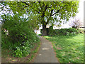
Path out of Corringham recreation ground
To Kenwood Road.
Image: © Robin Webster
Taken: 23 Apr 2017
0.13 miles
3
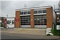
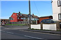
Corringham fire stationfire
Corringham fire station, 43 Fobbing Road, Corringham, Stanford-le-Hope, Essex
Image: © Kevin Hale
Taken: 27 Apr 2009
0.13 miles
4
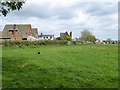
Recreation ground, Corringham
The north end of the ground.
Image: © Robin Webster
Taken: 23 Apr 2017
0.14 miles
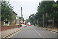
6
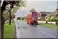
RT bus, Lampits Hill, 1990
Pausing on the way back from a rally, London RT buses never operated for real on this road. However, in former times green RTs came up Giffords Cross Road, but turned south into Church Road on route 349 from Grays to the oil refineries.
Image: © Robin Webster
Taken: Unknown
0.15 miles
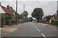
9
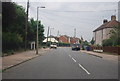
Approaching the end of Giffords Cross Rd
Image: © N Chadwick
Taken: 24 Aug 2012
0.18 miles