IMAGES TAKEN NEAR TO
Parry Close, STANFORD-LE-HOPE, SS17 8RD
Introduction
This page details the photographs taken nearby to Parry Close, SS17 8RD by members of the Geograph project.
The Geograph project started in 2005 with the aim of publishing, organising and preserving representative images for every square kilometre of Great Britain, Ireland and the Isle of Man.

There are currently over 7.5m images from over14,400 individuals and you can help contribute to the project by visiting https://www.geograph.org.uk
Image Map (Loading...)


Getting Data...Please wait
Leaflet Map data © OpenStreetMap
Images are licensed for reuse under creativecommons.org/licenses/by-sa/2.0
Notes
- Clicking on the map will re-center to the selected point.
- The higher the marker number, the further away the image location is from the centre of the postcode.
Image Listing (22 Images Found)
Images are licensed for reuse under creativecommons.org/licenses/by-sa/2.0
Image
Details
Distance
4
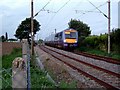
Train Passing Stanford le Hope
This shows one of C2C’s Class 357 units heading for Stanford le Hope Station. The photo was taken looking along the eastbound track where footpath 33 crosses the railway line. The railway line marks the northern boundary of development in Stanford le Hope.
Image: © Glyn Baker
Taken: 25 Sep 2005
0.17 miles
7
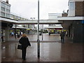
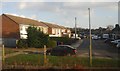
Corringham Shopping Centre
Taken on a cold and rainy day.
Image: © Hazel
Taken: 7 Mar 2006
0.20 miles
8
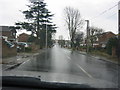
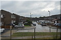
Branksome Avenue
Taken along Branksome Avenue.
Image: © Hazel
Taken: 7 Mar 2006
0.20 miles
10
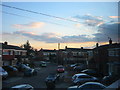
Sunset over Stanford Le Hope
This shot is taken from my house.
Image: © Hazel
Taken: 4 Mar 2006
0.20 miles