IMAGES TAKEN NEAR TO
Tallis Close, STANFORD-LE-HOPE, SS17 8QW
Introduction
This page details the photographs taken nearby to Tallis Close, SS17 8QW by members of the Geograph project.
The Geograph project started in 2005 with the aim of publishing, organising and preserving representative images for every square kilometre of Great Britain, Ireland and the Isle of Man.

There are currently over 7.5m images from over14,400 individuals and you can help contribute to the project by visiting https://www.geograph.org.uk
Image Map
Images are licensed for reuse under creativecommons.org/licenses/by-sa/2.0
Notes
- Clicking on the map will re-center to the selected point.
- The higher the marker number, the further away the image location is from the centre of the postcode.
Image Listing (17 Images Found)
Images are licensed for reuse under creativecommons.org/licenses/by-sa/2.0
Image
Details
Distance
6
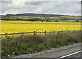
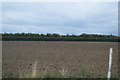
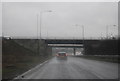
View Towards Langdon Hills
Looking across a field of Rape from the A13 close to the junction with the B1007.
Image: © Martin Addison
Taken: 25 Apr 2015
0.13 miles
9
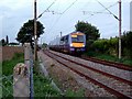
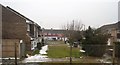
Train Passing Stanford le Hope
This shows one of C2C’s Class 357 units heading for Stanford le Hope Station. The photo was taken looking along the eastbound track where footpath 33 crosses the railway line. The railway line marks the northern boundary of development in Stanford le Hope.
Image: © Glyn Baker
Taken: 25 Sep 2005
0.18 miles