IMAGES TAKEN NEAR TO
North Hill, STANFORD-LE-HOPE, SS17 8QA
Introduction
This page details the photographs taken nearby to North Hill, SS17 8QA by members of the Geograph project.
The Geograph project started in 2005 with the aim of publishing, organising and preserving representative images for every square kilometre of Great Britain, Ireland and the Isle of Man.

There are currently over 7.5m images from over14,400 individuals and you can help contribute to the project by visiting https://www.geograph.org.uk
Image Map (Loading...)


Getting Data...Please wait
Leaflet Map data © OpenStreetMap
Images are licensed for reuse under creativecommons.org/licenses/by-sa/2.0
Notes
- Clicking on the map will re-center to the selected point.
- The higher the marker number, the further away the image location is from the centre of the postcode.
Image Listing (7 Images Found)
Images are licensed for reuse under creativecommons.org/licenses/by-sa/2.0
Image
Details
Distance
1
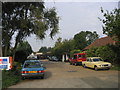
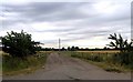
Brooklyn Farm Trading Estate, Horndon
The original farm has long gone - now home to a number of small businesses
Image: © John Winfield
Taken: 23 Sep 2005
0.08 miles
2

Pink Hawthorn
This blossom was beside footpath 10 south of Horndon on the Hill
Image: © Glyn Baker
Taken: 6 May 2011
0.13 miles
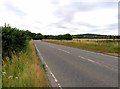
3
Towards Horndon on the Hill
This is the B1007.
Image: © Andrew Tatlow
Taken: 26 Jul 2013
0.14 miles
4
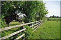
Footpath 10 to Hillcrest Rd
This footpath connects Hillcrest Rd and the A128
Image: © Glyn Baker
Taken: 6 May 2011
0.15 miles
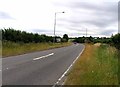
6
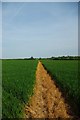
Footpath to Horndon
Footpath 10 is very clearly marked.
Image: © Glyn Baker
Taken: 6 May 2011
0.20 miles