IMAGES TAKEN NEAR TO
Horndon Road, STANFORD-LE-HOPE, SS17 8PF
Introduction
This page details the photographs taken nearby to Horndon Road, SS17 8PF by members of the Geograph project.
The Geograph project started in 2005 with the aim of publishing, organising and preserving representative images for every square kilometre of Great Britain, Ireland and the Isle of Man.

There are currently over 7.5m images from over14,400 individuals and you can help contribute to the project by visiting https://www.geograph.org.uk
Image Map
Images are licensed for reuse under creativecommons.org/licenses/by-sa/2.0
Notes
- Clicking on the map will re-center to the selected point.
- The higher the marker number, the further away the image location is from the centre of the postcode.
Image Listing (4 Images Found)
Images are licensed for reuse under creativecommons.org/licenses/by-sa/2.0
Image
Details
Distance
1
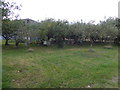
Beehives in orchard at Saffron Gardens
Image: © Alpin Stewart
Taken: 22 Sep 2018
0.05 miles
2
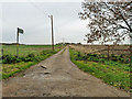
Track to Saffron Gardens
Also public footpath 11.
Image: © Robin Webster
Taken: 13 Nov 2010
0.23 miles
3
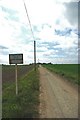
Footpath From Pump Street
Looking towards Saffron Gardens from Pump Street
Image: © Glyn Baker
Taken: 18 May 2011
0.24 miles
4
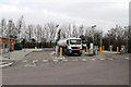
Stanford-le-Hope Services
The truck refuelling area at the eastbound services - with a BP fuel tanker fittingly using a BP service station (I believe it was the driver that needed refuelling on this occasion).
Image: © Martin Addison
Taken: 2 Mar 2013
0.24 miles