IMAGES TAKEN NEAR TO
Branksome Avenue, STANFORD-LE-HOPE, SS17 8BD
Introduction
This page details the photographs taken nearby to Branksome Avenue, SS17 8BD by members of the Geograph project.
The Geograph project started in 2005 with the aim of publishing, organising and preserving representative images for every square kilometre of Great Britain, Ireland and the Isle of Man.

There are currently over 7.5m images from over14,400 individuals and you can help contribute to the project by visiting https://www.geograph.org.uk
Image Map
Images are licensed for reuse under creativecommons.org/licenses/by-sa/2.0
Notes
- Clicking on the map will re-center to the selected point.
- The higher the marker number, the further away the image location is from the centre of the postcode.
Image Listing (20 Images Found)
Images are licensed for reuse under creativecommons.org/licenses/by-sa/2.0
Image
Details
Distance
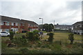
1
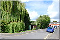
Silverdale
A cul-de-sac off Branksome Close, Stanford-le-Hope.
Image: © Trevor Harris
Taken: 7 May 2015
0.06 miles
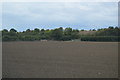
4
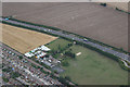
Greenacres Farm
Corringham, adjacent to the A13.
Image: © terry joyce
Taken: 18 Aug 2010
0.11 miles
7
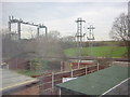
C2C train track at Stanford Le Hope
This is taken from my back garden.
Image: © Hazel
Taken: 27 Feb 2006
0.18 miles
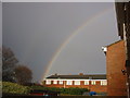
9
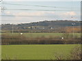
Stanford Le Hope landscape.
This is the view I see every morning.
Image: © Hazel
Taken: 4 Mar 2006
0.18 miles
10
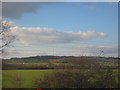
Panoramic view of Horndon on the Hill
Taken from Stanford le hope.
Image: © Hazel
Taken: 4 Mar 2006
0.18 miles