IMAGES TAKEN NEAR TO
Hawthorne Road, STANFORD-LE-HOPE, SS17 7TE
Introduction
This page details the photographs taken nearby to Hawthorne Road, SS17 7TE by members of the Geograph project.
The Geograph project started in 2005 with the aim of publishing, organising and preserving representative images for every square kilometre of Great Britain, Ireland and the Isle of Man.

There are currently over 7.5m images from over14,400 individuals and you can help contribute to the project by visiting https://www.geograph.org.uk
Image Map (Loading...)


Getting Data...Please wait
Leaflet Map data © OpenStreetMap
Images are licensed for reuse under creativecommons.org/licenses/by-sa/2.0
Notes
- Clicking on the map will re-center to the selected point.
- The higher the marker number, the further away the image location is from the centre of the postcode.
Image Listing (3 Images Found)
Images are licensed for reuse under creativecommons.org/licenses/by-sa/2.0
Image
Details
Distance
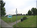
2
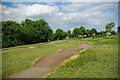
BMX Track in Corringham Town Park
Corringham Town Park is a small scrap of green surrounded by a large housing development
Image: © Glyn Baker
Taken: 19 May 2011
0.17 miles
3
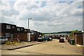
Briceway
An area of housing typical of Corringham the shot was taken looking roughly towards Image]
Image: © Glyn Baker
Taken: 19 May 2011
0.25 miles