IMAGES TAKEN NEAR TO
Harris Close, STANFORD-LE-HOPE, SS17 7QW
Introduction
This page details the photographs taken nearby to Harris Close, SS17 7QW by members of the Geograph project.
The Geograph project started in 2005 with the aim of publishing, organising and preserving representative images for every square kilometre of Great Britain, Ireland and the Isle of Man.

There are currently over 7.5m images from over14,400 individuals and you can help contribute to the project by visiting https://www.geograph.org.uk
Image Map (Loading...)


Getting Data...Please wait
Leaflet Map data © OpenStreetMap
Images are licensed for reuse under creativecommons.org/licenses/by-sa/2.0
Notes
- Clicking on the map will re-center to the selected point.
- The higher the marker number, the further away the image location is from the centre of the postcode.
Image Listing (17 Images Found)
Images are licensed for reuse under creativecommons.org/licenses/by-sa/2.0
Image
Details
Distance
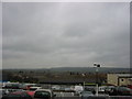
1
Dreary day over Corringham.
Taken from Corringham town centre Looking towards Horndon on the Hill on the horizon.
Image: © Hazel
Taken: 7 Mar 2006
0.08 miles
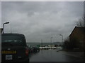
2
Cloudy skies over Corringham
Taken from the shopping centre. Horndon on the Hill is on the horizon.
Image: © Hazel
Taken: 7 Mar 2006
0.08 miles
3
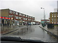
A rainy Corringham Town Centre
Taken at the entrance to the shopping centre.
Image: © Hazel
Taken: 7 Mar 2006
0.08 miles
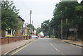
4
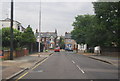
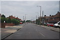
Approaching the end of Giffords Cross Rd
Image: © N Chadwick
Taken: 24 Aug 2012
0.09 miles
5
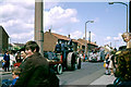
Corringham carnival, 1969
The traction engine was owned and steered by the local doctor.
Image: © Robin Webster
Taken: Unknown
0.10 miles