IMAGES TAKEN NEAR TO
Collins Close, STANFORD-LE-HOPE, SS17 7DD
Introduction
This page details the photographs taken nearby to Collins Close, SS17 7DD by members of the Geograph project.
The Geograph project started in 2005 with the aim of publishing, organising and preserving representative images for every square kilometre of Great Britain, Ireland and the Isle of Man.

There are currently over 7.5m images from over14,400 individuals and you can help contribute to the project by visiting https://www.geograph.org.uk
Image Map
Images are licensed for reuse under creativecommons.org/licenses/by-sa/2.0
Notes
- Clicking on the map will re-center to the selected point.
- The higher the marker number, the further away the image location is from the centre of the postcode.
Image Listing (8 Images Found)
Images are licensed for reuse under creativecommons.org/licenses/by-sa/2.0
Image
Details
Distance
2
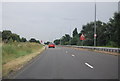
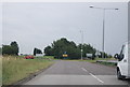
The end of Abbots Hall Chase
A pedestrian underpass goes under the A1014. Formerly the lane continued beyond to Abbots Hall, but this is long gone without apparent trace, built over by housing estates.
Image: © Robin Webster
Taken: 12 Dec 2013
0.08 miles
3
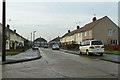
Webster Road, Stanford-le-Hope
The road is named after Charles Louis Webster, J.P., a Cambridgeshire man who moved south from the rural village of Over to seek his fortune, and became a prominent figure in the village here. He lived in Rectory Road and was buried in 1940 at the top end of the cemetery on Wharf Road. The graves of his parents and grandparents may be seen in the cemetery at Over - Image .
Image: © Robin Webster
Taken: 12 Dec 2013
0.13 miles
5
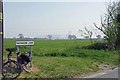
Winter Cereal by Rainbow Lane
Across the field through the haze the Image can be seen the
Image: © Glyn Baker
Taken: 9 Apr 2020
0.21 miles
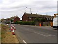
6
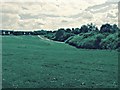
View from Upton Close
From the end of Upton Close off Abbotts Drive. Hidden by the trees ahead is The Monorway - the road to Coryton.
Image: © Trevor Harris
Taken: 7 May 2015
0.22 miles
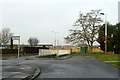
8

The Catcracker
A pub at the eastern end of The Sorrells.
Image: © Ron Galliers
Taken: 31 Jul 2008
0.24 miles