IMAGES TAKEN NEAR TO
Bevin Walk, STANFORD-LE-HOPE, SS17 0PD
Introduction
This page details the photographs taken nearby to Bevin Walk, SS17 0PD by members of the Geograph project.
The Geograph project started in 2005 with the aim of publishing, organising and preserving representative images for every square kilometre of Great Britain, Ireland and the Isle of Man.

There are currently over 7.5m images from over14,400 individuals and you can help contribute to the project by visiting https://www.geograph.org.uk
Image Map (8 Images)


Getting Data...Please wait
Leaflet Map data © OpenStreetMap
Images are licensed for reuse under creativecommons.org/licenses/by-sa/2.0
Notes
- Clicking on the map will re-center to the selected point.
- The higher the marker number, the further away the image location is from the centre of the postcode.
Image Listing (8 Images Found)
Images are licensed for reuse under creativecommons.org/licenses/by-sa/2.0
Image
Details
Distance
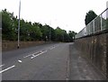
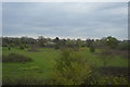
5
View from Upton Close
From the end of Upton Close off Abbotts Drive. Hidden by the trees ahead is The Monorway - the road to Coryton.
Image: © Trevor Harris
Taken: 7 May 2015
0.19 miles