IMAGES TAKEN NEAR TO
Old Jenkins Close, STANFORD-LE-HOPE, SS17 0NB
Introduction
This page details the photographs taken nearby to Old Jenkins Close, SS17 0NB by members of the Geograph project.
The Geograph project started in 2005 with the aim of publishing, organising and preserving representative images for every square kilometre of Great Britain, Ireland and the Isle of Man.

There are currently over 7.5m images from over14,400 individuals and you can help contribute to the project by visiting https://www.geograph.org.uk
Image Map (Loading...)


Getting Data...Please wait
Leaflet Map data © OpenStreetMap
Images are licensed for reuse under creativecommons.org/licenses/by-sa/2.0
Notes
- Clicking on the map will re-center to the selected point.
- The higher the marker number, the further away the image location is from the centre of the postcode.
Image Listing (9 Images Found)
Images are licensed for reuse under creativecommons.org/licenses/by-sa/2.0
Image
Details
Distance
2
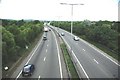
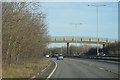
A13 Near Stanford-le-Hope
The picture was taken from the Image
Image: © Glyn Baker
Taken: 18 May 2011
0.17 miles
6
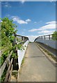
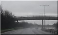
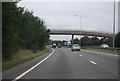
Footbridge on Bridleway 48
This bridge carries bridleway 48 over the A13 and connects Horndon of the Hill with Stanford-le-Hope
Image: © Glyn Baker
Taken: 18 May 2011
0.18 miles
9
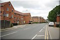
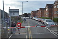
Flats on London Road
The far block of flats are retirement homes. Stanford would not be the very first place I would think of as a restful place to spend ones dotage!
Image: © Glyn Baker
Taken: 18 May 2011
0.25 miles