IMAGES TAKEN NEAR TO
London Road, STANFORD-LE-HOPE, SS17 0JU
Introduction
This page details the photographs taken nearby to London Road, SS17 0JU by members of the Geograph project.
The Geograph project started in 2005 with the aim of publishing, organising and preserving representative images for every square kilometre of Great Britain, Ireland and the Isle of Man.

There are currently over 7.5m images from over14,400 individuals and you can help contribute to the project by visiting https://www.geograph.org.uk
Image Map
Images are licensed for reuse under creativecommons.org/licenses/by-sa/2.0
Notes
- Clicking on the map will re-center to the selected point.
- The higher the marker number, the further away the image location is from the centre of the postcode.
Image Listing (62 Images Found)
Images are licensed for reuse under creativecommons.org/licenses/by-sa/2.0
Image
Details
Distance
1

Old Bridge Marker on Mucking Creek Bridge, Stanford le Hope parish
Bridge Marker by the UC road, in parish of Stanford Le Hope (Thurrock District), Mucking Creek Bridge, fixed to both North and South parapets - but missing from South parapet in November 2020.
Surveyed
Milestone Society National ID: EX_STLH01br
Image: © Milestone Society
Taken: Unknown
0.02 miles
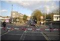
4
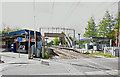
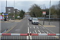
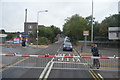
Level Crossing at Stanford-le-Hope
On the London Road side, looking towards Church Hill
Image: © Glyn Baker
Taken: 18 May 2011
0.04 miles
5
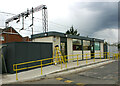
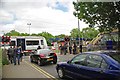
Temporary ticket office at Stanford-le-Hope station
Now that the station frontage Image has been demolished as part of the current rebuilding project the ticket office has been moved to a temporary site on the other side of the level crossing. Ironically this is where the original station was sited before being replaced by the now demolished parts about sixty years ago.
Image: © David Kemp
Taken: 5 May 2021
0.04 miles
7
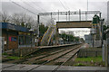
Stanford-le-Hope station
Shows the down (i.e. Southend) platform. The station was opened in 1854 and is on the Tilbury section (known these days as the Tilbury Loop) of the C2C line from London (Fenchurch Street) to Shoeburyness.
Image: © David Kemp
Taken: 1 Jan 2012
0.05 miles
8
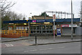
Stanford-le-Hope station entrance
The original Stanford-le-Hope station was opened in 1854 on a site on the opposite (north) side of London Road to where the present station stands. The station was moved and rebuilt on the latter site in conjunction with the electrification of the Tilbury Loop of the line from London (Fenchurch Street) to Shoeburyness. Planning permission has now been given for a further rebuild of the station on its present site which will involve the demolition and replacement of the building seen here.
Image: © David Kemp
Taken: 1 Jan 2012
0.05 miles