IMAGES TAKEN NEAR TO
SS17 0GR
Introduction
This page details the photographs taken nearby to SS17 0GR by members of the Geograph project.
The Geograph project started in 2005 with the aim of publishing, organising and preserving representative images for every square kilometre of Great Britain, Ireland and the Isle of Man.

There are currently over 7.5m images from over14,400 individuals and you can help contribute to the project by visiting https://www.geograph.org.uk
Image Map
Images are licensed for reuse under creativecommons.org/licenses/by-sa/2.0
Notes
- Clicking on the map will re-center to the selected point.
- The higher the marker number, the further away the image location is from the centre of the postcode.
Image Listing (57 Images Found)
Images are licensed for reuse under creativecommons.org/licenses/by-sa/2.0
Image
Details
Distance
1
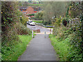
Going down the brook
Before the housing development across Stanford Brook, this was the unsurfaced way down for vehicles, with a wood surfaced bridge. There were only allotments on the other side, with the road layout as now but only as tracks, evidently laid out for future development which for many years only managed to reach two houses (now demolished).
Image: © Robin Webster
Taken: 13 Nov 2010
0.07 miles
3
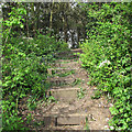
Bluebell Steps, Grove House Wood, Stanford-le-Hope
Looking up steps featuring early flowering bluebells, on a footpath in Grove House Wood. A small local nature reserve in Stanford-le-Hope, owned by Thurrock Council and managed by Essex Wildlife Trust http://www.wildessex.net/sites/Grove%20House%20Wood.htm
See also:
Image
Image
Image: © Roger Jones
Taken: 5 Apr 2014
0.10 miles
4
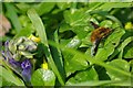
Bee Fly
This Bee fly (Bombylius major) was living in Image its larvae feed on the larvae of solitary bees.
Image: © Glyn Baker
Taken: 15 Apr 2009
0.10 miles
5

Speckled Wood in Grove House Wood
This Speckled wood (Pararge aegria) was one of Several I saw in Image
Image: © Glyn Baker
Taken: 15 Apr 2009
0.11 miles
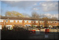
6
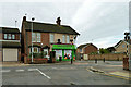
Hadfield Stores
On the corner of Wharf Road and Hadfield Road.
Image: © Robin Webster
Taken: 13 Nov 2010
0.11 miles
7
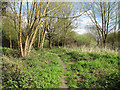
Near the river in Grove House Wood, Stanford-le-Hope
Close to the River Hassenbrooke in Grove House Wood, a small local nature reserve in Stanford-le-Hope, owned by Thurrock Council and managed by Essex Wildlife Trust http://www.wildessex.net/sites/Grove%20House%20Wood.htm
See also:
Image
Image
Image: © Roger Jones
Taken: 5 Apr 2014
0.11 miles
8
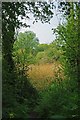
Grove House Wood
This nature reserve is just a few minutes walk from the centre of Stanford Le Hope. The Six acres are owned by Thurrock Council and managed by Essex Wildlife trust http://www.essexwt.org.uk/ . See more pictures at http://www.geograph.org.uk/search.php?i=34352135 or continue on a virtual tour of Wildlife Trust Reserves in Essex
by visiting Image
Image: © Glyn Baker
Taken: 15 Apr 2009
0.14 miles
9
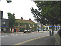
Stanford-le-Hope, Essex
The old ivy clad pub in the centre is called "The Inn on the Green" - but where is the green?
Image: © John Winfield
Taken: 23 Sep 2005
0.14 miles
10
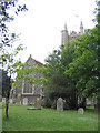
Parish Church, Stanford-le-Hope, Essex
Image: © John Winfield
Taken: 23 Sep 2005
0.15 miles