IMAGES TAKEN NEAR TO
Brookfield Drive, SS17 0GL
Introduction
This page details the photographs taken nearby to Brookfield Drive, SS17 0GL by members of the Geograph project.
The Geograph project started in 2005 with the aim of publishing, organising and preserving representative images for every square kilometre of Great Britain, Ireland and the Isle of Man.

There are currently over 7.5m images from over14,400 individuals and you can help contribute to the project by visiting https://www.geograph.org.uk
Image Map
Images are licensed for reuse under creativecommons.org/licenses/by-sa/2.0
Notes
- Clicking on the map will re-center to the selected point.
- The higher the marker number, the further away the image location is from the centre of the postcode.
Image Listing (15 Images Found)
Images are licensed for reuse under creativecommons.org/licenses/by-sa/2.0
Image
Details
Distance
4
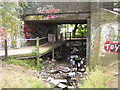
Stanford-le-Hope: Railway bridge
This bridge takes the railway line over Stanford Stream and a footpath just north of Stanford-le-Hope station. The stream flows down through the centre of the town from here and into the River Thames at Mucking Creek. Amongst the debris on display in the stream are a moped and a kiddy's cycle, whilst a pink armchair partially blocks the footpath...
Image: © Nigel Cox
Taken: 11 Aug 2006
0.12 miles
5
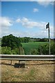
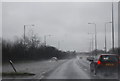
Footpath to Stanford-le-Hope
This footpath links the A13/A1013/A1014 Junction with Victoria Road in Stanford-le-Hope
Image: © Glyn Baker
Taken: 18 May 2011
0.12 miles
6
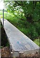
Official Footbridge
This rather rickety construction is the official crossing over the stream that runs beside the Image For the more intrepid there is an even more challenging Image near Image
Image: © Glyn Baker
Taken: 18 May 2011
0.13 miles
7
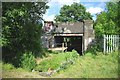
Unofficial Footbridge
The Image runs under the railway on the far side of the stream. Someone has placed a convenient log across it for walkers who missed the Image
Image: © Glyn Baker
Taken: 18 May 2011
0.14 miles
9
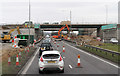
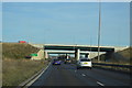
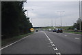
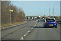
Improving Access
Roadworks for the London Gateway Project which aims to increase the traffic capacity of the A13 / A1014 junction sufficiently to offset the traffic that may be generated by London Gateway Port and Logistics Park. The nearest 'south' bridge is to be demolished and replaced with one carrying 3 lanes - the new abutments are taking shape on both sides of the A13. The farther 'north' bridge will have its width increased to 3 lanes.
Image: © Martin Addison
Taken: 2 Mar 2013
0.19 miles