IMAGES TAKEN NEAR TO
Stanhope Industrial Estate, Wharf Road, STANFORD-LE-HOPE, SS17 0EH
Introduction
This page details the photographs taken nearby to Stanhope Industrial Estate, Wharf Road, SS17 0EH by members of the Geograph project.
The Geograph project started in 2005 with the aim of publishing, organising and preserving representative images for every square kilometre of Great Britain, Ireland and the Isle of Man.

There are currently over 7.5m images from over14,400 individuals and you can help contribute to the project by visiting https://www.geograph.org.uk
Image Map
Images are licensed for reuse under creativecommons.org/licenses/by-sa/2.0
Notes
- Clicking on the map will re-center to the selected point.
- The higher the marker number, the further away the image location is from the centre of the postcode.
Image Listing (5 Images Found)
Images are licensed for reuse under creativecommons.org/licenses/by-sa/2.0
Image
Details
Distance
1
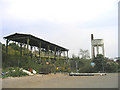
Derelict Industrial Works, Stanford-le-Hope
The embankment on the left carries the single track Thames Haven branch line, which had a siding to this site (see Image) which is now totally derelict. The site was originally a Fisons plant which produced ammonium nitrate from ammonia piped in from the adjacent Shell Haven refinery. The product was loaded in liquid form at the gantry on the left into steam-heated insulated rail tank cars and transported in block trains to other Fisons fertilizer works at Immingham and Avonmouth.
Image: © John Winfield
Taken: 23 Sep 2005
0.02 miles
2

Water tower on disused industrial site
Seen from the nature reserve.
Image: © Trevor Harris
Taken: 27 May 2013
0.05 miles
3
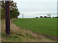
Field south of Stanford-le-Hope
The water tower of the former Fisons fertilizer works looms over the rise.
Image: © Robin Webster
Taken: 13 Nov 2010
0.10 miles
4
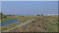
New coastal footpath at Stanford-le-Hope
Coastal footpath at Mucking Flats is now re-routed inland.
Coryton Oil Refinery can be seen in distance on right.
Image: © Essex Walks
Taken: 3 Oct 2011
0.23 miles
5
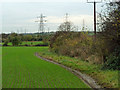
Footpath from Rainbow Lane to Wharf Road
A field edge path, rather muddy after November rain.
Image: © Robin Webster
Taken: 13 Nov 2010
0.24 miles