
IMAGES TAKEN NEAR TO
The Warren, Wharf Road, STANFORD-LE-HOPE, SS17 0EG
Introduction
This page details the photographs taken nearby to The Warren, Wharf Road, SS17 0EG by members of the Geograph project.
The Geograph project started in 2005 with the aim of publishing, organising and preserving representative images for every square kilometre of Great Britain, Ireland and the Isle of Man.

There are currently over 7.5m images from over14,400 individuals and you can help contribute to the project by visiting https://www.geograph.org.uk
Image Map
Images are licensed for reuse under creativecommons.org/licenses/by-sa/2.0
Notes
- Clicking on the map will re-center to the selected point.
- The higher the marker number, the further away the image location is from the centre of the postcode.
Image Listing (21 Images Found)
Images are licensed for reuse under creativecommons.org/licenses/by-sa/2.0
Image
Details
Distance
2
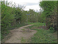
Footpath signpost in Stanford Warren Nature Reserve, Mucking
The signpost shows the bend in the public footpath in Stanford Warren Nature Reserve, Mucking. The reserve, managed by Essex Wildlife Trust, has one of the largest reedbeds in Essex, created by gravel extraction in the 1920s, together with areas of marsh and rough grassland. The south of the reserve now adjoins the newer Thurrock Thameside Nature Park.
Essex Wildlife Trust: http://www.essexwt.org.uk/reserves/stanford-warren
Wild Essex: http://www.wildessex.net/sites/Stanford%20Warren.htm
Image: © Roger Jones
Taken: 5 Apr 2014
0.17 miles
4
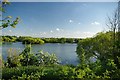
Lake at Stanford Warren
Fishing lakes abound round here since gravel extraction ceased
Image: © Glyn Baker
Taken: 2 May 2011
0.18 miles
5
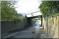
Railway bridge across Wharf Road, Stanford-le-Hope
This carries the freight-only branch from the C2C main line at Thames Haven Junction to the port at Thames Gateway. The branch was once part of a local light railway network that carried both passengers and freight in connection with the munitions, petro-chemical and oil refining plants that once existed in the area. With the coming of the Thames Gateway regeneration project in the early 2000s and the creation of the port, the line gained a new lease of life (and was double-tracked).
Image: © David Kemp
Taken: 5 May 2021
0.19 miles
6
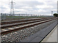
Double Track to Shell Haven & London Gateway
Compare to: Image
Most likely double tracked as part of the development of the London Gateway port.
Image: © Roger Jones
Taken: 5 Apr 2014
0.19 miles
7

Whitethroat Near Sanford Warren
At first from the song I could hear I thought I had found a lazy lark! I plumped for Reed Warbler but a birder of repute has given a positive I.D of Whitethroat. This one was close to Stanford Warren Nature Reserve see Image
Image: © Glyn Baker
Taken: 2 May 2011
0.19 miles
8

Orange Tip
This male Image was flying in Image an Essex Wildlife Trust reserve http://www.essexwt.org.uk/visitor_centres__nature_reserves/stanford_warren_nature_reserve/
Image: © Glyn Baker
Taken: 14 Apr 2009
0.20 miles
9

Anthocharis cardamines
This male Image was flying in Image an Essex Wildlife Trust reserve http://www.essexwt.org.uk/visitor_centres__nature_reserves/stanford_warren_nature_reserve/
Image: © Glyn Baker
Taken: 14 Apr 2009
0.20 miles
10
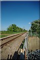
Single Track to Shell Haven
This is the Image as it passes through Stanford-le-Hope
Image: © Glyn Baker
Taken: 2 May 2011
0.20 miles