IMAGES TAKEN NEAR TO
Billet Lane, STANFORD-LE-HOPE, SS17 0AJ
Introduction
This page details the photographs taken nearby to Billet Lane, SS17 0AJ by members of the Geograph project.
The Geograph project started in 2005 with the aim of publishing, organising and preserving representative images for every square kilometre of Great Britain, Ireland and the Isle of Man.

There are currently over 7.5m images from over14,400 individuals and you can help contribute to the project by visiting https://www.geograph.org.uk
Image Map (Loading...)


Getting Data...Please wait
Leaflet Map data © OpenStreetMap
Images are licensed for reuse under creativecommons.org/licenses/by-sa/2.0
Notes
- Clicking on the map will re-center to the selected point.
- The higher the marker number, the further away the image location is from the centre of the postcode.
Image Listing (4 Images Found)
Images are licensed for reuse under creativecommons.org/licenses/by-sa/2.0
Image
Details
Distance
2
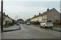
Webster Road, Stanford-le-Hope
The road is named after Charles Louis Webster, J.P., a Cambridgeshire man who moved south from the rural village of Over to seek his fortune, and became a prominent figure in the village here. He lived in Rectory Road and was buried in 1940 at the top end of the cemetery on Wharf Road. The graves of his parents and grandparents may be seen in the cemetery at Over - Image .
Image: © Robin Webster
Taken: 12 Dec 2013
0.16 miles
3
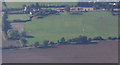
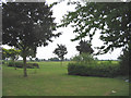
Aerial view of The Billet Public House
The Billet Public House and Sports Ground.
Image: © terry joyce
Taken: 19 Oct 2007
0.22 miles
4
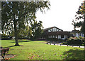
The Billet Public House, Corringham
The Billet was formerly known as the Crooked Billet.
The Sports Ground is next to the Pub. See aerial photo Image
Image: © terry joyce
Taken: 18 Oct 2007
0.22 miles