IMAGES TAKEN NEAR TO
Rye Mead, BASILDON, SS16 6LJ
Introduction
This page details the photographs taken nearby to Rye Mead, SS16 6LJ by members of the Geograph project.
The Geograph project started in 2005 with the aim of publishing, organising and preserving representative images for every square kilometre of Great Britain, Ireland and the Isle of Man.

There are currently over 7.5m images from over14,400 individuals and you can help contribute to the project by visiting https://www.geograph.org.uk
Image Map
Images are licensed for reuse under creativecommons.org/licenses/by-sa/2.0
Notes
- Clicking on the map will re-center to the selected point.
- The higher the marker number, the further away the image location is from the centre of the postcode.
Image Listing (17 Images Found)
Images are licensed for reuse under creativecommons.org/licenses/by-sa/2.0
Image
Details
Distance
1
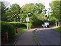
Delmores
Delmores leads from Laindon High Road to the Marks Hill Nature Reserve and housing.
Image: © William Metcalfe
Taken: 15 May 2007
0.02 miles
2
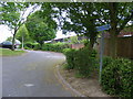
Puckleside
A street named after a 19th century farmer, Puckle, who left money for the first school in Langdon Hills.
Image: © William Metcalfe
Taken: 27 Apr 2007
0.03 miles
3
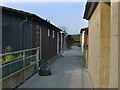
Housing estate in Langdon Hills
Rubbish collection day for these chalet style houses in Puckleside.
Image: © William Metcalfe
Taken: 25 Apr 2007
0.05 miles
4
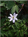
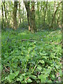
Wood anemone
The white anemones produce a bright early spring display in Marks Hill Wood.
Image: © William Metcalfe
Taken: 21 Apr 2007
0.06 miles
5
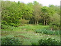
Doctor's Pond
One of several ponds in the Langdon Nature Reserve which is in danger of drying out and reverting to woodland. There is abundant plant growth within it which demands annual clearance to preserve it as a pond. A good frog watching spot in March.
Image: © William Metcalfe
Taken: 24 Apr 2007
0.12 miles
6
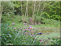
Beauty and the Beast
Contrast the beauty of the red campions in the foreground with the discarded fuel tank floating in Doctor's Pond in the Langdon Nature Reserve.
Image: © William Metcalfe
Taken: 24 Apr 2007
0.12 miles
7
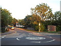
Mini-roundabout near Laindon
A mini-roundabout at the junction of High Road and Valence Way, near Laindon.
This image was taken on a late August evening as the sun was setting.
Image: © Malc McDonald
Taken: 27 Aug 2017
0.13 miles
8
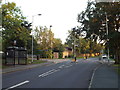
High Road, Langdon Hills, near Laindon
A view southwards along High Road at Langdon Hills, on the outskirts of Basildon.
Image: © Malc McDonald
Taken: 27 Aug 2017
0.14 miles
9
Yellow archangel
Yellow archangel, lamiastrum galeobdolon, a flower indicative of ancient woodland, resembles a nettle with bright-yellow flowers. Growing here just yards from a Langdon Hills housing estate.
Image: © William Metcalfe
Taken: 18 Apr 2007
0.14 miles
10
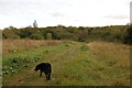
Marks Hill Nature Reserve
Most of the reserve is wooded. Here the path crosses a more open area.
Image: © Trevor Harris
Taken: 11 Oct 2011
0.17 miles