IMAGES TAKEN NEAR TO
Old Hill Avenue, BASILDON, SS16 6JE
Introduction
This page details the photographs taken nearby to Old Hill Avenue, SS16 6JE by members of the Geograph project.
The Geograph project started in 2005 with the aim of publishing, organising and preserving representative images for every square kilometre of Great Britain, Ireland and the Isle of Man.

There are currently over 7.5m images from over14,400 individuals and you can help contribute to the project by visiting https://www.geograph.org.uk
Image Map
Images are licensed for reuse under creativecommons.org/licenses/by-sa/2.0
Notes
- Clicking on the map will re-center to the selected point.
- The higher the marker number, the further away the image location is from the centre of the postcode.
Image Listing (4 Images Found)
Images are licensed for reuse under creativecommons.org/licenses/by-sa/2.0
Image
Details
Distance
1
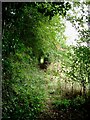
Light at The End of The Tunnel
This picture shows footpath 33 from South Hill on the B1007 to Green Trees Farm. At this point it passes through a tunnel of trees.
Image: © Glyn Baker
Taken: 24 Sep 2005
0.18 miles
2
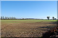
Langdon Hills
The Anglo-Saxon word "don" means "a low hill in open countryside". A pretty accurate description of this view of Langdon Hills.
Image: © John Matthews
Taken: 15 Oct 2009
0.22 miles
3
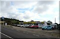
South Hill Garage
On South Hill (B1007)
Showing position of Postbox No. SS16 411.
See Image] for postbox.
Image: © JThomas
Taken: 23 Aug 2022
0.23 miles
4
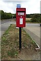
Elizabeth II postbox on South Hill (B1007)
Postbox No. SS16 411.
See Image] for context.
Image: © JThomas
Taken: 23 Aug 2022
0.24 miles