IMAGES TAKEN NEAR TO
Witchards, BASILDON, SS16 5BQ
Introduction
This page details the photographs taken nearby to Witchards, SS16 5BQ by members of the Geograph project.
The Geograph project started in 2005 with the aim of publishing, organising and preserving representative images for every square kilometre of Great Britain, Ireland and the Isle of Man.

There are currently over 7.5m images from over14,400 individuals and you can help contribute to the project by visiting https://www.geograph.org.uk
Image Map
Images are licensed for reuse under creativecommons.org/licenses/by-sa/2.0
Notes
- Clicking on the map will re-center to the selected point.
- The higher the marker number, the further away the image location is from the centre of the postcode.
Image Listing (24 Images Found)
Images are licensed for reuse under creativecommons.org/licenses/by-sa/2.0
Image
Details
Distance
1
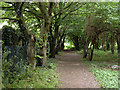
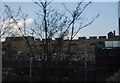
Path towards Clay Hill Road, Basildon
One of the more obscure walking routes close to the town centre.
Image: © Robin Webster
Taken: 28 May 2017
0.04 miles
2
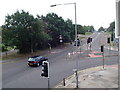
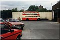
Clayhill Road at the junction with Cherrydown
Photographed from the first floor of the Thamesway bus depot.
Image: © Paul Francis
Taken: 27 Aug 2000
0.10 miles
3
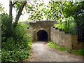
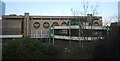
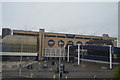
Path under railway, Basildon
Before the new town of Basildon came on the scene, this was a bridge for a stream only. Unless the stream has been completely diverted, it must now pass under the path.
Image: © Robin Webster
Taken: 28 May 2017
0.12 miles