IMAGES TAKEN NEAR TO
Mid Colne, BASILDON, SS16 4DQ
Introduction
This page details the photographs taken nearby to Mid Colne, SS16 4DQ by members of the Geograph project.
The Geograph project started in 2005 with the aim of publishing, organising and preserving representative images for every square kilometre of Great Britain, Ireland and the Isle of Man.

There are currently over 7.5m images from over14,400 individuals and you can help contribute to the project by visiting https://www.geograph.org.uk
Image Map
Images are licensed for reuse under creativecommons.org/licenses/by-sa/2.0
Notes
- Clicking on the map will re-center to the selected point.
- The higher the marker number, the further away the image location is from the centre of the postcode.
Image Listing (10 Images Found)
Images are licensed for reuse under creativecommons.org/licenses/by-sa/2.0
Image
Details
Distance
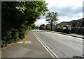
3
Church Road, Vange
Looking south along Church Road towards its junction with Clay Hill Road.
Image: © Trevor Harris
Taken: 14 Jun 2010
0.20 miles
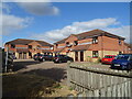
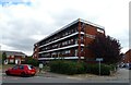
4
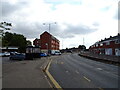
Corner shops with flats, Basildon
On the corner of Clay Hill Road and Church Road.
Image: © Robin Webster
Taken: 28 May 2017
0.20 miles

6
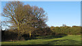
Vange Hill Open Space
For another picture from Vange Hill Open Space see: http://www.geograph.org.uk/photo/3420826
Image: © Roger Jones
Taken: 20 Apr 2013
0.21 miles
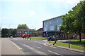
8
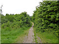
Path, Vange Hill Open Space
30 acres of former plotlands lying next to Basildon golf course.
Image: © Robin Webster
Taken: 28 May 2017
0.23 miles
9
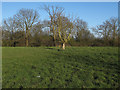
Vange Hill Open Space
For another picture from Vange Hill Open Space see: http://www.geograph.org.uk/photo/3420829
Image: © Roger Jones
Taken: 20 Apr 2013
0.24 miles
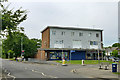
10
Bus stop and shelter on Clay Hill Road, Basildon
Image: © JThomas
Taken: 23 Aug 2022
0.24 miles