IMAGES TAKEN NEAR TO
Vange Hill Drive, BASILDON, SS16 4DA
Introduction
This page details the photographs taken nearby to Vange Hill Drive, SS16 4DA by members of the Geograph project.
The Geograph project started in 2005 with the aim of publishing, organising and preserving representative images for every square kilometre of Great Britain, Ireland and the Isle of Man.

There are currently over 7.5m images from over14,400 individuals and you can help contribute to the project by visiting https://www.geograph.org.uk
Image Map (Loading...)


Getting Data...Please wait
Leaflet Map data © OpenStreetMap
Images are licensed for reuse under creativecommons.org/licenses/by-sa/2.0
Notes
- Clicking on the map will re-center to the selected point.
- The higher the marker number, the further away the image location is from the centre of the postcode.
Image Listing (16 Images Found)
Images are licensed for reuse under creativecommons.org/licenses/by-sa/2.0
Image
Details
Distance
1
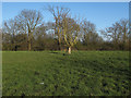
Vange Hill Open Space
For another picture from Vange Hill Open Space see: http://www.geograph.org.uk/photo/3420829
Image: © Roger Jones
Taken: 20 Apr 2013
0.16 miles
2
Vange Hill Open Space
For another picture from Vange Hill Open Space see: http://www.geograph.org.uk/photo/3420826
Image: © Roger Jones
Taken: 20 Apr 2013
0.18 miles
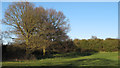
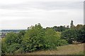
3
Vange Hill
Vange Hill is a 30 acre public open space owned by Basildon council. The free draining soil supports both pale and fairy flax. Its most notable feature is the view across the marshes.
Image: © Glyn Baker
Taken: 5 Sep 2010
0.18 miles
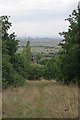
5
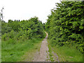
Path, Vange Hill Open Space
30 acres of former plotlands lying next to Basildon golf course.
Image: © Robin Webster
Taken: 28 May 2017
0.19 miles
6
Vange Hill Park
Image was once a "plotland" where "Eastenders" had holiday homes.
Image: © Glyn Baker
Taken: 5 Sep 2010
0.20 miles
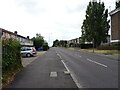
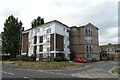
9
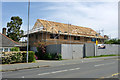
Building site, Clay Hill Road
This is on the site of a quite modern and smart detached bungalow flanked by a double garage, thus having a long frontage attractive for intensive redevelopment.
Image: © Robin Webster
Taken: 28 May 2017
0.21 miles
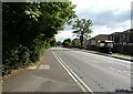
10
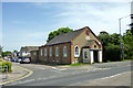
Gordon Mission Hall, Clay Hill Road
Dated 1901, it seems to be more concerned with child care now. The land on which it stands was given on condition it be named after General Gordon (Charles George Gordon, 28/01/1833 - 26/01/1885).
Image: © Robin Webster
Taken: 28 May 2017
0.22 miles