IMAGES TAKEN NEAR TO
Great Oxcroft, BASILDON, SS15 6PN
Introduction
This page details the photographs taken nearby to Great Oxcroft, SS15 6PN by members of the Geograph project.
The Geograph project started in 2005 with the aim of publishing, organising and preserving representative images for every square kilometre of Great Britain, Ireland and the Isle of Man.

There are currently over 7.5m images from over14,400 individuals and you can help contribute to the project by visiting https://www.geograph.org.uk
Image Map
Images are licensed for reuse under creativecommons.org/licenses/by-sa/2.0
Notes
- Clicking on the map will re-center to the selected point.
- The higher the marker number, the further away the image location is from the centre of the postcode.
Image Listing (35 Images Found)
Images are licensed for reuse under creativecommons.org/licenses/by-sa/2.0
Image
Details
Distance
3
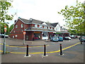
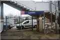
Station Gate Shopping Centre, Laindon
This parade of shops opposite Laindon Station is named Laindon Gate Shopping Centre.
Image: © Malc McDonald
Taken: 16 May 2015
0.12 miles
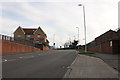
4
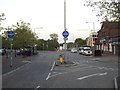
Laindon station approach
The blue signs indicate that the station approach road can only be used by buses, taxis and cycles.
Image: © Malc McDonald
Taken: 16 May 2015
0.13 miles
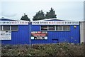

9
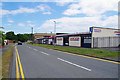
Industrial Units in Durham Rd
The taller brick building in the background is an office block called West Point.
Image: © Glyn Baker
Taken: 15 Jun 2020
0.15 miles