IMAGES TAKEN NEAR TO
Tate Close, BASILDON, SS15 5BE
Introduction
This page details the photographs taken nearby to Tate Close, SS15 5BE by members of the Geograph project.
The Geograph project started in 2005 with the aim of publishing, organising and preserving representative images for every square kilometre of Great Britain, Ireland and the Isle of Man.

There are currently over 7.5m images from over14,400 individuals and you can help contribute to the project by visiting https://www.geograph.org.uk
Image Map (10 Images)


Getting Data...Please wait
Leaflet Map data © OpenStreetMap
Images are licensed for reuse under creativecommons.org/licenses/by-sa/2.0
Notes
- Clicking on the map will re-center to the selected point.
- The higher the marker number, the further away the image location is from the centre of the postcode.
Image Listing (10 Images Found)
Images are licensed for reuse under creativecommons.org/licenses/by-sa/2.0
Image
Details
Distance
1
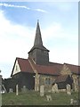
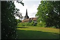
St Nicholas church - Laindon
The exact date of construction of the present St Nicholas Church is not known but it is believed to have been built during the 13th Century. The present church, or at least, the nave, must have been standing by 1254, when the first recorded rector, Richard de List, is known to have been at St Nicholas, although nothing else is known of him.
Image: © Andrew Pickess
Taken: 7 Sep 2005
0.11 miles
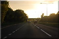
4
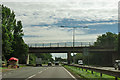
A127 - overbridge at Laindon
This bridge enabled the Fortune of War roundabout to be closed to crossing, right turning and U turning traffic, although it is still open as a chicane at left turn only T-junctions divorced by the central reservation.
Image: © Robin Webster
Taken: 22 Jul 2012
0.22 miles
5
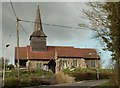
St. Nicholas; the parish church of Laindon
This church is mainly 14th century, but on the west end of the church there is a small two-storeyed wooden structure known as the Priest's House that was added in the 17th century. The church stands on very high ground and it is quite a landmark. Laindon is one of a handful of Essex villages that was swallowed up by Basildon new town.
Image: © Robert Edwards
Taken: 31 Mar 2008
0.22 miles
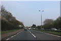
7
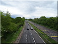
A127 eastbound, Basildon
Looking east from the bridge on Willowfield.
Image: © JThomas
Taken: 11 May 2019
0.23 miles
8
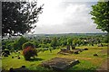
St Nicholas Churchyard
Image Stands on Church Hill there are fantastic views across urban Basildon and to the countryside beyond
Image: © Glyn Baker
Taken: 19 May 2011
0.23 miles
9
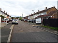
St Nicholas Laindon (with Dunton)
This rural scene is in the heart of Image
Image: © Glyn Baker
Taken: 19 May 2011
0.23 miles