IMAGES TAKEN NEAR TO
Shaftesbury Avenue, SOUTHEND-ON-SEA, SS1 3AL
Introduction
This page details the photographs taken nearby to Shaftesbury Avenue, SS1 3AL by members of the Geograph project.
The Geograph project started in 2005 with the aim of publishing, organising and preserving representative images for every square kilometre of Great Britain, Ireland and the Isle of Man.

There are currently over 7.5m images from over14,400 individuals and you can help contribute to the project by visiting https://www.geograph.org.uk
Image Map
Images are licensed for reuse under creativecommons.org/licenses/by-sa/2.0
Notes
- Clicking on the map will re-center to the selected point.
- The higher the marker number, the further away the image location is from the centre of the postcode.
Image Listing (56 Images Found)
Images are licensed for reuse under creativecommons.org/licenses/by-sa/2.0
Image
Details
Distance
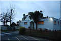
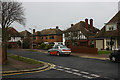
1
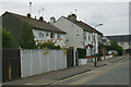
Shaftesbury Avenue, Thorpe Bay
As Shaftesbury Avenue progresses eastward the houses become newer. These date from the inter-War years and are situated near the eastern extremity of the road.
Image: © David Kemp
Taken: 5 Jan 2014
0.04 miles
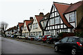
2
Plas Newydd, Southend
Despite its name this is not a suburban road in Wales. For many years I've wondered why this street in Southend was so named but am still none the wiser. The turning that can just be made out near the far end is the equally oddly-named Capadocia Street. Taken from Shaftesbury Avenue looking towards the estuary.
Image: © David Kemp
Taken: 15 Sep 2013
0.07 miles
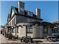
5
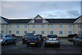
Capadocia Street, Southend
I have no idea why this very unpretentious cul-de-sac should have been given such an exotic name. Nor do I know why the road from which I took the shot should have been called Plas Newydd. The building at the far end is the Premier Inn.
Image: © David Kemp
Taken: 15 Sep 2013
0.08 miles
6
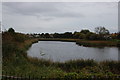
Lake, Southchurch Park
The park is divided into east and west by Lifstan Way which runs across it north to south. This is the lake in Southchurch Park East.
Image: © Trevor Harris
Taken: 12 Oct 2014
0.08 miles
7
Colbert Avenue, Thorpe Bay
Taken from the top of Warwick Road.
Image: © David Kemp
Taken: 5 Jan 2014
0.09 miles
8
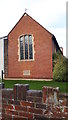
The Parish Church of Christ Church, Southend-on -Sea
Image: © V1ncenze
Taken: 1 Dec 2019
0.09 miles