IMAGES TAKEN NEAR TO
Woodgrange Drive, SOUTHEND-ON-SEA, SS1 2SQ
Introduction
This page details the photographs taken nearby to Woodgrange Drive, SS1 2SQ by members of the Geograph project.
The Geograph project started in 2005 with the aim of publishing, organising and preserving representative images for every square kilometre of Great Britain, Ireland and the Isle of Man.

There are currently over 7.5m images from over14,400 individuals and you can help contribute to the project by visiting https://www.geograph.org.uk
Image Map
Images are licensed for reuse under creativecommons.org/licenses/by-sa/2.0
Notes
- Clicking on the map will re-center to the selected point.
- The higher the marker number, the further away the image location is from the centre of the postcode.
Image Listing (22 Images Found)
Images are licensed for reuse under creativecommons.org/licenses/by-sa/2.0
Image
Details
Distance
1
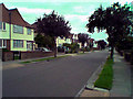
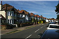
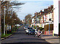
Southend-on-Sea: Huntingdon Road north of Woodgrange Drive looking South
These properties are typical of the eastward expansion of Southend-on-Sea in the late 1920s. The houses depicted are semi-detached with three bedrooms. Many of these homes were built by local builder Southend Estates and benefit from large rear gardens of 60-80 feet in length and parking to the front. This is a rare scene indeed with no cars parked in the road!
Image: © Trevor Durritt
Taken: 12 Jan 2009
0.11 miles
2
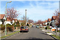
Southend-on-Sea: Huntingdon Road north of Woodgrange Drive looking North
These properties are typical of the eastward expansion of Southend-on-Sea in the late 1920s. Most houses are semi-detached with houses on the right and bungalows on the left. Many of these homes were built by local builder Southend Estates and benefit from large rear gardens of 60-80 feet in length and parking to the front.
Image: © Trevor Durritt
Taken: 2 Mar 2008
0.12 miles
3
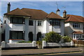
Seaside semi-detached suburbia, Northumberland Crescent, Southchurch, Southend-on-Sea
Image: © Christopher Hilton
Taken: 22 Jun 2014
0.14 miles
4
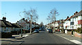
Southend-on-Sea Ambleside Drive looking West 2008
Typical of housing in the local area built in the late 1920s. Most are three or four bedroomed semi-detached houses. A few bungalows were also built at this time and can be seen on the left. The Shoeburyness to London Fenchurch Street railway line runs behind the houses on the right.
Image: © Trevor Durritt
Taken: 17 Feb 2008
0.15 miles
5
Northumberland Crescent, Southchurch, Southend-on-Sea
Image: © Christopher Hilton
Taken: 22 Jun 2014
0.15 miles
6
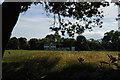
Cricket pavilion, Southchurch Park
Image: © Christopher Hilton
Taken: 22 Jun 2014
0.17 miles
7
Southend-on-Sea: Rutland Avenue north of Woodgrange Drive looking North
These properties are typical of the eastward expansion of Southend-on-Sea in the late 1920s. Most houses are semi-detached and 3 or four bedrooms. There are a couple of detached properties and some bungalows towards the top of the road on the left. Many of these homes were built by local builder Thorby and benefit from large rear gardens of 60-80 feet in length and parking to the front.
Image: © Trevor Durritt
Taken: 17 Feb 2008
0.18 miles
8
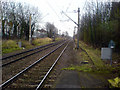
Southend-on-Sea: From Southend East Station looking east
Taken from the eastern end of the south platform (platform 1) looking east. The houses on the left of the picture are in Riviera Drive. Just after the picture was taken, Network Rail removed the trees on the left and cause a public outcry.
Image: © Trevor Durritt
Taken: 23 Feb 2008
0.20 miles
9

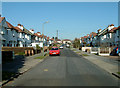
Southchurch Park - NW corner
The houses are on Northumberland Crescent.
Image: © Robin Webster
Taken: 12 Dec 2013
0.21 miles
10
Southend-on-Sea: Riviera Drive looking West 2008
This is a view looking west from the junction at the eastern end with the railway line that runs between London Fenchurch Street and Shoeburyness on the left. These terraced houses are typical of those built in the late nineteenth century. I was brought up in this area until I married in my early twenties. Most back gardens are about twenty five feet long.
Image: © Trevor Durritt
Taken: 2 Mar 2008
0.21 miles