IMAGES TAKEN NEAR TO
Glebe Road, WICKFORD, SS11 8EU
Introduction
This page details the photographs taken nearby to Glebe Road, SS11 8EU by members of the Geograph project.
The Geograph project started in 2005 with the aim of publishing, organising and preserving representative images for every square kilometre of Great Britain, Ireland and the Isle of Man.

There are currently over 7.5m images from over14,400 individuals and you can help contribute to the project by visiting https://www.geograph.org.uk
Image Map (Loading...)


Getting Data...Please wait
Leaflet Map data © OpenStreetMap
Images are licensed for reuse under creativecommons.org/licenses/by-sa/2.0
Notes
- Clicking on the map will re-center to the selected point.
- The higher the marker number, the further away the image location is from the centre of the postcode.
Image Listing (17 Images Found)
Images are licensed for reuse under creativecommons.org/licenses/by-sa/2.0
Image
Details
Distance
1
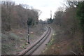
Southminster Branch-line
East from Wickford
Image: © John Myers
Taken: 12 Jan 2012
0.14 miles

4
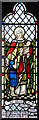
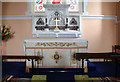
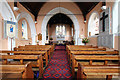
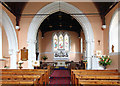
St Catherine, Wickford - Stained glass window
Image: © John Salmon
Taken: 28 May 2014
0.16 miles
6
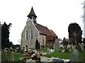
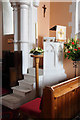
St Catherine's Wickford
This is St Catherine’s Church Wickford. The church stands on raised ground to the side of the A129 Southend Rd.
Image: © Glyn Baker
Taken: 24 Feb 2006
0.16 miles
7
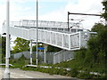
Railway Footbridge
Railway Footbridge between Salcott Crescent and Russell Gardens, Wickford
Image: © Stan Wray
Taken: 10 Aug 2008
0.16 miles
9

Bell tower, St Catherine's Church, Wickford
Image: © Jim Osley
Taken: 26 Sep 2013
0.17 miles