IMAGES TAKEN NEAR TO
Farm Crescent, WICKFORD, SS11 7QP
Introduction
This page details the photographs taken nearby to Farm Crescent, SS11 7QP by members of the Geograph project.
The Geograph project started in 2005 with the aim of publishing, organising and preserving representative images for every square kilometre of Great Britain, Ireland and the Isle of Man.

There are currently over 7.5m images from over14,400 individuals and you can help contribute to the project by visiting https://www.geograph.org.uk
Image Map (Loading...)


Getting Data...Please wait
Leaflet Map data © OpenStreetMap
Images are licensed for reuse under creativecommons.org/licenses/by-sa/2.0
Notes
- Clicking on the map will re-center to the selected point.
- The higher the marker number, the further away the image location is from the centre of the postcode.
Image Listing (4 Images Found)
Images are licensed for reuse under creativecommons.org/licenses/by-sa/2.0
Image
Details
Distance
1

Footpath From Marks Farm
This is the footpath that runs from Woodham Rd to Marks Farm. The photo was taken looking towards Woodham Road. I believe the building on the right to be a water pumping station however there were no signs to indicate ownership.
Image: © Glyn Baker
Taken: 19 Feb 2006
0.02 miles
2
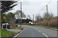
Woodham Road, Rettendon
The main road to Burnham before being bypassed over this part by the current A132 route.
Image: © Robin Webster
Taken: 25 Mar 2018
0.05 miles
3
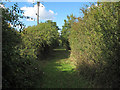
Footpath to Woodham Road
Footpath between Burnham Road and Woodham Road.
Image: © Roger Jones
Taken: 14 Oct 2012
0.09 miles
4
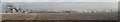
Hoar frost on trees and farmland in south east Essex. Panorama
Looking east from Rettendon Village along the Crouch valley towards Burnham on Crouch.
Image: © Homermeyn
Taken: 12 Dec 2012
0.20 miles