IMAGES TAKEN NEAR TO
Lynfords Avenue, WICKFORD, SS11 7PX
Introduction
This page details the photographs taken nearby to Lynfords Avenue, SS11 7PX by members of the Geograph project.
The Geograph project started in 2005 with the aim of publishing, organising and preserving representative images for every square kilometre of Great Britain, Ireland and the Isle of Man.

There are currently over 7.5m images from over14,400 individuals and you can help contribute to the project by visiting https://www.geograph.org.uk
Image Map (Loading...)


Getting Data...Please wait
Leaflet Map data © OpenStreetMap
Images are licensed for reuse under creativecommons.org/licenses/by-sa/2.0
Notes
- Clicking on the map will re-center to the selected point.
- The higher the marker number, the further away the image location is from the centre of the postcode.
Image Listing (3 Images Found)
Images are licensed for reuse under creativecommons.org/licenses/by-sa/2.0
Image
Details
Distance
1
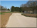
Construction site, former Runwell Hospital
Planning permission has been granted to develop a new residential area on parts of the former Runwell Hospital Site. Here you can see a new road surface which has been recently laid.
see also: Image]
Image: © Roger Jones
Taken: 18 Apr 2015
0.19 miles
2
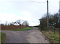
Lynfords Drive
This is a private road the public footpath does not run up this road, the path runs parallel to the west. The path access is gained via a stile off of the A132 and runs up behind the properties on this road. It actually follows the line of the overhead power cables.
Image: © terry joyce
Taken: 28 Dec 2011
0.20 miles
3
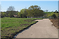
Construction site, former Runwell Hospital
Planning permission has been granted to develop a new residential area on parts of the former Runwell Hospital Site. Here you can see a new road surface which has been recently laid.
see also: Image]
Image: © Roger Jones
Taken: 18 Apr 2015
0.23 miles