IMAGES TAKEN NEAR TO
Lynfords Drive, WICKFORD, SS11 7PP
Introduction
This page details the photographs taken nearby to Lynfords Drive, SS11 7PP by members of the Geograph project.
The Geograph project started in 2005 with the aim of publishing, organising and preserving representative images for every square kilometre of Great Britain, Ireland and the Isle of Man.

There are currently over 7.5m images from over14,400 individuals and you can help contribute to the project by visiting https://www.geograph.org.uk
Image Map (Loading...)


Getting Data...Please wait
Leaflet Map data © OpenStreetMap
Images are licensed for reuse under creativecommons.org/licenses/by-sa/2.0
Notes
- Clicking on the map will re-center to the selected point.
- The higher the marker number, the further away the image location is from the centre of the postcode.
Image Listing (8 Images Found)
Images are licensed for reuse under creativecommons.org/licenses/by-sa/2.0
Image
Details
Distance
1
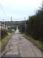
Lynfords Drive
The OS map seemed to show access to a footpath from this road. This is not the case.
Image: © terry joyce
Taken: 28 Dec 2011
0.05 miles
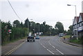
3
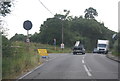
The Chase and A132
This is the A132 in Runwell at the junction with “The Chase”. The photo was taken looking along the A132 towards Wickford
Image: © Glyn Baker
Taken: 24 Feb 2006
0.13 miles
4
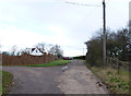
Lynfords Drive
This is a private road the public footpath does not run up this road, the path runs parallel to the west. The path access is gained via a stile off of the A132 and runs up behind the properties on this road. It actually follows the line of the overhead power cables.
Image: © terry joyce
Taken: 28 Dec 2011
0.14 miles
5
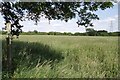
Footpath To Battlesbridge
This path runs from Runwell Rd to Battlesbridge
Image: © Glyn Baker
Taken: 29 Jun 2013
0.16 miles
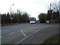
7
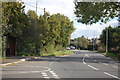
Runwell Road
Looking east from the southern end of The Chase.
Image: © Trevor Harris
Taken: 20 Oct 2014
0.20 miles
8
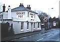
The Quart Pot, Runwell
Pub on the Runwell Road.
Image: © John Myers
Taken: 25 Feb 2007
0.23 miles