IMAGES TAKEN NEAR TO
Howards Way, WICKFORD, SS11 7FA
Introduction
This page details the photographs taken nearby to Howards Way, SS11 7FA by members of the Geograph project.
The Geograph project started in 2005 with the aim of publishing, organising and preserving representative images for every square kilometre of Great Britain, Ireland and the Isle of Man.

There are currently over 7.5m images from over14,400 individuals and you can help contribute to the project by visiting https://www.geograph.org.uk
Image Map (5 Images)


Getting Data...Please wait
Leaflet Map data © OpenStreetMap
Images are licensed for reuse under creativecommons.org/licenses/by-sa/2.0
Notes
- Clicking on the map will re-center to the selected point.
- The higher the marker number, the further away the image location is from the centre of the postcode.
Image Listing (5 Images Found)
Images are licensed for reuse under creativecommons.org/licenses/by-sa/2.0
Image
Details
Distance
1
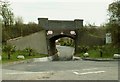
Railway Bridge over Hayes Chase
On the other side of the bridge lies a caravan site.
Image: © Robert Edwards
Taken: 9 Apr 2008
0.06 miles
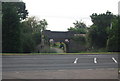
3
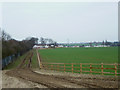
Hayes Farm Caravan Park
Taken from the footpath between the A132 Burnham Road, Rettendon and Battlesbridge.
It looks like they are putting in a new access road to the Caravan Park.
Image: © terry joyce
Taken: 28 Feb 2012
0.15 miles
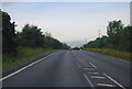
5
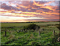
Sunset over Battlesbridge.
Evening view from the car park at the end of Marsh Farm Road. The pylons can be seen on the horizon, these trace the B1012.
Image: © TREVOR NORRIS
Taken: 4 Oct 2006
0.25 miles