IMAGES TAKEN NEAR TO
Crowstone Avenue, WESTCLIFF-ON-SEA, SS0 8HT
Introduction
This page details the photographs taken nearby to Crowstone Avenue, SS0 8HT by members of the Geograph project.
The Geograph project started in 2005 with the aim of publishing, organising and preserving representative images for every square kilometre of Great Britain, Ireland and the Isle of Man.

There are currently over 7.5m images from over14,400 individuals and you can help contribute to the project by visiting https://www.geograph.org.uk
Image Map
Images are licensed for reuse under creativecommons.org/licenses/by-sa/2.0
Notes
- Clicking on the map will re-center to the selected point.
- The higher the marker number, the further away the image location is from the centre of the postcode.
Image Listing (50 Images Found)
Images are licensed for reuse under creativecommons.org/licenses/by-sa/2.0
Image
Details
Distance
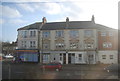
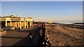
1
Houses, Crowstone Avenue and Second Avenue
Image: © Robin Webster
Taken: 1 Oct 2018
0.02 miles
2
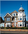
Westcliff-on-Sea : Crowstone House
"Crowstone House, the most prominent building in the [Crowstone] conservation area was built in 1905 as a house but it was subsequently extended and converted to a ladies school by a Miss O’Meara in 1913. It is now a care home." Quoted from this https://www.southend.gov.uk/info/200422/conservation_areas/401/crowstone_conservation_area.
Image: © Jim Osley
Taken: 27 Sep 2018
0.09 miles
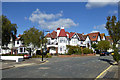
3
Crowstone House
'Senior Living' on the seafront.
Image: © Robin Webster
Taken: 1 Oct 2018
0.09 miles
4
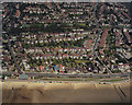
Aerial view of Southend seafront: Chalkwell Esplanade
The shelter just behind the beach on the left marks the end (or beginning) of the Esplanade as a main road (going on to Shoebury). The road from the shelter running along the left is Chalkwell Avenue, which reaches the A13 (London Road) at Chalkwell Park.
The previous (eastern) photo in this sequence is Image The next (western) photo is Image
Image: © Edward Clack
Taken: 26 May 1988
0.11 miles
5
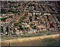
Aerial view of Southend seafront: Paddling pool and Chalkwell Esplanade
The paddling pool lies to the right of the photo. The esplanade at the right is the western Esplanade, that on the left is Chalkwell Esplanade.
The previous (eastern) photo in this sequence is Image The next (western) photo is Image
Image: © Edward Clack
Taken: 26 May 1988
0.11 miles
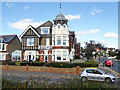
7
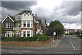
Crowstone Avenue, Chalkwell
The rather grand house on the corner of Crowstone Avenue and Chalkwell Esplanade is called Crowstone House.
Image: © Stephen McKay
Taken: 27 Aug 2011
0.11 miles
9
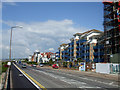
The Leas
This is a section of the seafront road called The Leas. The building site on the right of the picture is on the junction with Grosvenor Road.
The building with blue balconies is called Admirals Place.
Image: © terry joyce
Taken: 17 May 2010
0.12 miles