IMAGES TAKEN NEAR TO
Palmerston Road, WESTCLIFF-ON-SEA, SS0 7TA
Introduction
This page details the photographs taken nearby to Palmerston Road, SS0 7TA by members of the Geograph project.
The Geograph project started in 2005 with the aim of publishing, organising and preserving representative images for every square kilometre of Great Britain, Ireland and the Isle of Man.

There are currently over 7.5m images from over14,400 individuals and you can help contribute to the project by visiting https://www.geograph.org.uk
Image Map (Loading...)


Getting Data...Please wait
Leaflet Map data © OpenStreetMap
Images are licensed for reuse under creativecommons.org/licenses/by-sa/2.0
Notes
- Clicking on the map will re-center to the selected point.
- The higher the marker number, the further away the image location is from the centre of the postcode.
Image Listing (47 Images Found)
Images are licensed for reuse under creativecommons.org/licenses/by-sa/2.0
Image
Details
Distance
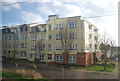
2
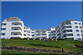
Argyll House
Art Deco flats on the front at Westcliff.
Image: © william
Taken: 23 May 2010
0.06 miles
3
Station Road, Westcliff on Sea
Seen from the bottom of Valkyrie Road with the Lamb & Lion pub ahead.
Image: © Stephen McKay
Taken: 27 Aug 2011
0.07 miles
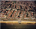
5
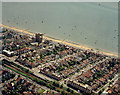
Aerial view of Southend seafront: Westcliff station and seafront
Westcliff station lies just at the centre-left of the photo, with the railway running to the bottom-centre.
The previous (eastern) photo in this sequence is Image The next (western) photo is Image
Image: © Edward Clack
Taken: 26 May 1988
0.07 miles
6
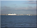
End of a ferry
This view looks across the Thames from Allhallows-on-Sea to Westcliff-on-Sea. Between the two is the Pride of Dover on its final trip from Tilbury Docks to be broken up in Turkey. The former Dover to Calais ferry had been laid up in Tilbury for two years hoping for a buyer, but none materialised. The trip would take four weeks and would be pulled the whole way by the tug at the front. The Port of London Authority tug at the back would be shortly detached. For more information on the Pride of Dover and its fate see http://en.wikipedia.org/wiki/MS_Pride_of_Dover
Image: © Marathon
Taken: 29 Nov 2012
0.07 miles
8
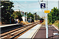
Special steam train approaching Westcliff station, 2000
45407 (running as 45157) is hauling a 'Cockney Coaster' bank holiday weekend shuttle service from Fenchurch Street to Shoeburyness. It is non-stop through Westcliff.
Image: © Robin Webster
Taken: 28 Aug 2000
0.09 miles
9

Aerial view of Southend seafront: Cliffs Pavilion westward
The Cliffs Pavilion lies at the left of the photo. The seafront here continues on towards Chalkwell. The railway line runs from the bottom-left to right centre, with the bottom of Hamlet Court Road crossing it at the right (by Westcliff Station) and Milton Road crossing it at the left.
The previous (eastern) photo in the sequence is Image The next (western) photo is Image
Image: © Edward Clack
Taken: 26 May 1988
0.10 miles
10
Aerial view of Southend seafront: Western Esplanade west to paddling pool
The mass of houses is suburban Westcliff. The paddling pool lies to the left of the beach.
The previous (eastern) photo in this sequence is Image The next (western) photo is Image
Image: © Edward Clack
Taken: 26 May 1988
0.11 miles