IMAGES TAKEN NEAR TO
Carlingford Drive, WESTCLIFF-ON-SEA, SS0 0SD
Introduction
This page details the photographs taken nearby to Carlingford Drive, SS0 0SD by members of the Geograph project.
The Geograph project started in 2005 with the aim of publishing, organising and preserving representative images for every square kilometre of Great Britain, Ireland and the Isle of Man.

There are currently over 7.5m images from over14,400 individuals and you can help contribute to the project by visiting https://www.geograph.org.uk
Image Map (Loading...)


Getting Data...Please wait
Leaflet Map data © OpenStreetMap
Images are licensed for reuse under creativecommons.org/licenses/by-sa/2.0
Notes
- Clicking on the map will re-center to the selected point.
- The higher the marker number, the further away the image location is from the centre of the postcode.
Image Listing (13 Images Found)
Images are licensed for reuse under creativecommons.org/licenses/by-sa/2.0
Image
Details
Distance
1
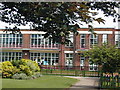
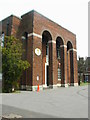
Earl's Hall Junior School
Built in the 1920s to serve the housing which developed around here at the time. The style reflects the healthy light and airy theories of education at that time.
Image: © Bob Bowyer
Taken: Unknown
0.11 miles
2
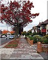
Hobleythick Lane
Autumn colour in this busy suburban street.
Image: © John Myers
Taken: 2 Nov 2007
0.12 miles
3
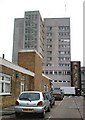
Southend Hospital - The Towerblock
Ugly concrete monolith not flattered by this view from a service road at the rear.
Image: © John Myers
Taken: 12 Sep 2006
0.12 miles
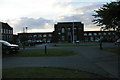
4
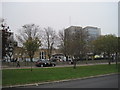
Southend Hospital
Showing Accident & Emergency and the Tower block.
Image: © Julian P Guffogg
Taken: 11 Oct 2012
0.13 miles
5
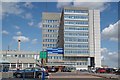
Southend University Hospital
This is the main Tower Block entrance to this extensive regional hospital. www.southend.nhs.uk
Image: © Glyn Baker
Taken: 20 Aug 2019
0.14 miles
6
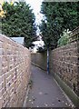
Pedestrian Cut - through
Alley between Earl's Hall Avenue and Hobleythick Lane.
Image: © John Myers
Taken: 2 Nov 2007
0.16 miles
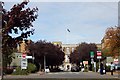
7
Southend Grammar School for Boys
The magnificent front arches of this grammar school - complete with traffic cone. Always rivalled Westcliff High, a few miles west, and Fairfax, the secondary modern down the road.
Image: © Bob Bowyer
Taken: Unknown
0.16 miles
8
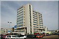
Tower Block, Southend Hospital
The Tower Block opened in 1971. The Accident & Emergency facility is on the far left.
Image: © David Kemp
Taken: 31 Mar 2021
0.17 miles
9
Southend High School for Boys
Dating from the inter-war period, when much of this area was developed.
Image: © Christopher Hilton
Taken: 21 Jun 2014
0.18 miles
10
Southend Hospital Entrance
Before the building of the tower block, which now incorporates the main entrance, this entry facing Prittlewell Chase, was the main way in to the hospital.
Image: © Trevor Harris
Taken: 2 Oct 2009
0.18 miles