IMAGES TAKEN NEAR TO
PETERLEE, SR8 2YB
Introduction
This page details the photographs taken nearby to SR8 2YB by members of the Geograph project.
The Geograph project started in 2005 with the aim of publishing, organising and preserving representative images for every square kilometre of Great Britain, Ireland and the Isle of Man.

There are currently over 7.5m images from over14,400 individuals and you can help contribute to the project by visiting https://www.geograph.org.uk
Image Map
Images are licensed for reuse under creativecommons.org/licenses/by-sa/2.0
Notes
- Clicking on the map will re-center to the selected point.
- The higher the marker number, the further away the image location is from the centre of the postcode.
Image Listing (8 Images Found)
Images are licensed for reuse under creativecommons.org/licenses/by-sa/2.0
Image
Details
Distance
1
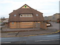
William Brown Centre, Peterlee
This photograph shows a view of the William Brown Centre on Manor Way, Peterlee. The building has an unusual roof that looks like a set of intersecting pyramids. This picture was taken from the opposite side of the road looking in a north-easterly direction.
Image: © Philip Barker
Taken: 17 Jan 2010
0.07 miles
3
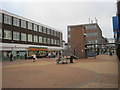
Pedestrian area in Castle Dene Shopping Centre at Peterlee
Image: © Peter Robinson
Taken: 14 Nov 2011
0.10 miles
5
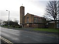
Peterlee Methodist Church
This photograph shows a view of Peterlee Methodist Church in Bede Way, Peterlee. The picture was taken looking in a west-south-westerly direction from the opposite side of the road.
Image: © Philip Barker
Taken: 17 Jan 2010
0.12 miles
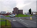
6
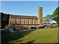
Peterlee Memorial Methodist Church
Part of the new town
Image: © Kevin Waterhouse
Taken: 13 Jun 2023
0.12 miles
7
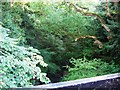
Blunts Beck
Blunts Beck as it passes through North Blunts in the town centre of Peterlee.
Image: © Graham Scarborough
Taken: 7 Jul 2007
0.19 miles
8
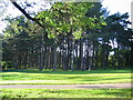
Scots Pine
A small Plantation of Scots Pine adjacent to Burnhope way, in the centre of Peterlee.
Image: © Graham Scarborough
Taken: 7 Jul 2007
0.20 miles