IMAGES TAKEN NEAR TO
Cold Hesledon, SEAHAM, SR7 8RL
Introduction
This page details the photographs taken nearby to SR7 8RL by members of the Geograph project.
The Geograph project started in 2005 with the aim of publishing, organising and preserving representative images for every square kilometre of Great Britain, Ireland and the Isle of Man.

There are currently over 7.5m images from over14,400 individuals and you can help contribute to the project by visiting https://www.geograph.org.uk
Image Map
Images are licensed for reuse under creativecommons.org/licenses/by-sa/2.0
Notes
- Clicking on the map will re-center to the selected point.
- The higher the marker number, the further away the image location is from the centre of the postcode.
Image Listing (8 Images Found)
Images are licensed for reuse under creativecommons.org/licenses/by-sa/2.0
Image
Details
Distance
2
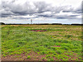
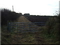
Cold Hesledon Deserted Medieval Village
Not much to see. Just a field with lots of humps and bumps. Unusually the field is enclosed by a cast iron fence which must be due to its historical significance.
For more details see http://www.keystothepast.info/Pages/pgDetail.aspx?PRN=D6 which indicates a medieval desertion. This was a period of general population contraction throughout the country due to successive crop failures, plagues and in this are of the north east incursions by Scottish raiders.
Image: © Mick Garratt
Taken: 7 Jul 2016
0.11 miles
3
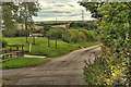
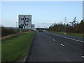
Field entrance off the A182
Footpath to South Farm.
Image: © JThomas
Taken: 10 Nov 2012
0.16 miles
6
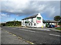
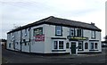
View of the Pemberton Arms, Cold Heseldon
Looking north along the B1432, the road leading to Seaham. The pub would seem to be late Victorian, as it is shown on the 1901 Ordnance Survey map, but not the 1862 one.
Image: © Robert Graham
Taken: 9 Oct 2013
0.22 miles